Pedways
Indoor Urban Walking Networks
~~~~~~~~~~~~~~
Victoria Transport Policy Institute
~~~~~~~~~~~~~~~~~~~~
Updated 29 May 2015
This chapter describes Pedways, which are enclosed urban walking networks that connect buildings and transportation terminals.
Description
Pedways (also called Skyways) are networks of indoor urban walkways, often elevated or underground, connecting buildings and other common destinations, particularly shopping centers, and transportation terminals such as bus and rail stations. They provide a convenient and comfortable (they are generally heated in winter and cooled in summer) way for pedestrians to travel around a city separated from traffic and inclement weather. They improve downtown Walkability and transit access, particularly in very cold, hot or wet climates.
How it is Implemented
Pedways often develop incrementally over time as buildings are constructed and connected to each other and transportation terminals.
Travel Impacts
Pedways improve Walkability and support Public Transit travel. They help create and maintain dense, pedestrian and transit-oriented downtowns.
Table 2 Travel Impact Summary
|
Objective |
Rating |
Comments |
|
Reduces total traffic. |
2 |
Reduces total per capita vehicle travel. |
|
Reduces peak period traffic. |
2 |
Reduces total per capita vehicle travel. |
|
Shifts peak to off-peak periods. |
0 |
|
|
Shifts automobile travel to alternative modes. |
2 |
Reduces total per capita vehicle travel. |
|
Improves access, reduces the need for travel. |
3 |
Supports higher-density, mixed land use. |
|
Increased ridesharing. |
2 |
Encourages alternatives to driving. |
|
Increased public transit. |
3 |
Encourages alternatives to driving. |
|
Increased cycling. |
1 |
Encourages alternatives to driving. |
|
Increased walking. |
3 |
Encourages alternatives to driving. |
|
Increased Telework. |
0 |
Encourages alternatives to driving. |
|
Reduced freight traffic. |
0 |
|
Rating from 3 (very beneficial) to –3 (very harmful). A 0 indicates no impact or mixed impacts.
Benefits And Costs
They improve Pedestrian Level-of-Service, that is, the quality of walking conditions experienced by users. Pedways can significantly increase downtown walking and public transit travel, and so help reduce traffic problems such as congestion and pollution emissions. By reducing the need to cross busy streets they can reduce pedestrian accident risks.
Costs include construction and maintenance costs. Some critics complain that Pedways separate pedestrians from public streets and limit the urban walking experience, for example, by excluding panhandlers and street performers. Security is sometimes a concern.
Table 3 Benefit Summary
|
Objective |
Rating |
Comments |
|
Congestion Reduction |
2 |
Reduces total automobile use. |
|
Road & Parking Savings |
2 |
Reduces total automobile ownership and use. |
|
Consumer Savings |
2 |
Reduces total transportation expenditures. |
|
Transport Choice |
3 |
Makes driving more affordable. |
|
Road Safety |
3 |
Reduces total automobile use. |
|
Environmental Protection |
2 |
Reduces total automobile use. |
|
Efficient Land Use |
2 |
Supports reduced automobile ownership. |
|
Community Livability |
2 |
Reduces total automobile use. |
Rating from 3 (very beneficial) to –3 (very harmful). A 0 indicates no impact or mixed impacts.
Equity Impacts
Pedways improve downtown walkability and transit access, which tends to benefit people who are economically and physically disadvantaged. However, they may exclude some disadvantaged people, such as panhandlers.
Table 4 Equity Summary
|
Criteria |
Rating |
Comments |
|
Treats everybody equally. |
1 |
|
|
Individuals bear the costs they impose. |
-1 |
May require subsidies to become established. |
|
Progressive with respect to income. |
3 |
Improve mobility options for lower-income people. |
|
Benefits transportation disadvantaged. |
3 |
Improve mobility options for some transportation disadvantaged people. |
|
Improves basic mobility. |
3 |
Improves access to downtown destinations. |
Rating from 3 (very beneficial) to –3 (very harmful). A 0 indicates no impact or mixed impacts.
Applications
Pedways are generally implemented in major urban centers, although variations may be possible in suburban and campus conditions. They are generally implemented by local governments and developers.
Table 5 Application Summary
|
Geographic |
Rating |
Organization |
Rating |
|
Large urban region. |
1 |
Federal government. |
1 |
|
High-density, urban. |
3 |
State/provincial government. |
1 |
|
Medium-density, urban/suburban. |
1 |
Regional government. |
1 |
|
Town. |
1 |
Municipal/local government. |
3 |
|
Low-density, rural. |
0 |
Business Associations/TMA. |
3 |
|
Commercial center. |
3 |
Individual business. |
2 |
|
Residential neighborhood. |
1 |
Developer. |
2 |
|
Resort/recreation area. |
1 |
Neighborhood association. |
1 |
|
|
|
Campus. |
2 |
Ratings range from 0 (not appropriate) to 3 (very appropriate).
Category
Improved Travel Option
Relationships With Other TDM Strategies
Pedways are a type of Walkability Improvement, which involves Nonmotorized Planning and Managing Nonmotorized Facilities. Pedestrian transportation supports most other TDM strategies, particularly Transit and Ridesharing, and Smart Growth. Universal Design means that nonmotorized transportation improvements accommodate a wide range of users, including people with disabilities. Pedway use is supported by Commute Trip Reduction programs, Parking Management, Transportation Access Guides, Traffic Calming, New Urbanism, and Transit Oriented Development. Addressing Security Concerns can be an important part of improving walkability.
Stakeholders
Pedways are usually implemented by local governments in cooperation with developers, businesses associations and individual businesses.
Barriers To Implementation
Pedways require planning and coordination among local governments, developers and businesses.
Best Practices
Pedways should be well designed to maximize Walkability, Universal Design and Transit Accessibility.
|
“The right to have access to every building in the city by private motorcar, in an age when everyone possesses such a vehicle, is actually the right to destroy the city.” - Lewis Mumford, 1981 |
Case Studies and Examples
Calgary, Alberta (http://en.wikipedia.org/wiki/%2B15)
The Plus 15 or +15 Pedway network in Calgary is considered the world's most extensive Pedway system with a total length of 16 kilometers (10 mi) and 59 bridges connecting buildings. The system is so named because the skywalks are approximately 15 feet (approximately 5 metres) above street level.
Montreal (www.jtlu.org/index.php/jtlu/article/view/176/176)
Montréal’s Indoor City is one of the most expansive indoor pedestrian networks in the world, extending for more than 32 kilometers (19.88 miles) and covering an area of twelve square kilometers (4.6 square miles) in the city’s downtown. This network provides numerous benefits including improved access throughout the downtown; shorter pedestrian walking distances; year-round climate protection; and increased amounts of public spaces.
The Indoor City was primarily developed by the private sector; consequently, its growth has been linked to the economic development of Montréal. However, a series of policies over the past five decades—including emphyteutic leases over new Metro stations, FAR exemptions for underground construction, and, more recently, the development of the QIM and the improvement of RÉSO signage, have also had significant effects on the pace at which the Indoor City has grown. It appears that a series of policies and events explain the exponential function of the network growth model. For instance, the network growth curve’s rapid rise in the 1960s can be associated with what has been called the Quiet Revolution in Quebec, under which Jean Lesage encouraged francophone Quebecers to engage in business. Additionally, Montréal Mayor Jean Drapeau’s ability to attract large international events and support for the Metro allowed the Indoor City to ourish. This was followed by a series of expansions in 1970s that accompanied the Olympic Games in 1976. The relatively stability or inactivity seen in the network growth curve during the 1980s can be explained by the hardships that the Québec economy experienced as a consequence of debt and political
Edmonton, Alberta (http://en.wikipedia.org/wiki/Edmonton_Pedway)
The Edmonton Pedway system is a network of pedestrian pedways and tunnels connecting to various office buildings, shopping centres, and parkades around the city’s downtown. It consists of around 13 km of year-round climate-controlled pedways connecting to more than 40 buildings and parkades. It is also connected to 3 of the 5 Edmonton Light Rail Transit (LRT) stations in the downtown.
Toronto’s PATH System
PATH is a 27-kilometre network of pedestrian tunnels connecting buildings and transportation terminals in downtown Toronto (Figure 1). It is considered the largest underground shopping complex in the world with 371,600 square metres of retail space. The PATH network’s northerly point is the Toronto Coach Terminal at Dundas and Bay Streets, while its southerly point is the Metro Toronto Convention Centre's Convention South Building.
Figure 1 Toronto Pedway Map (www.toronto.ca/path/pdf/path_brochure.pdf)
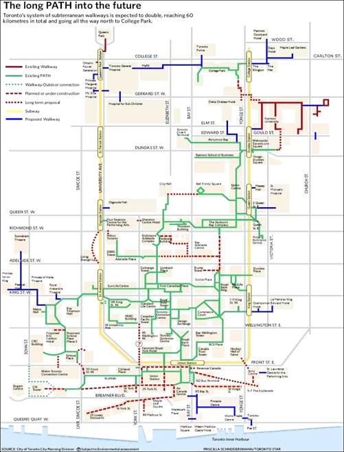
PATH is considered the world’s largest underground shopping center.
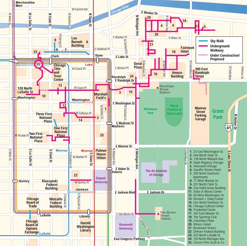
Chicago (www.spiegl.org/pedway/pedway.html)
The city of Chicago has an extensive Pedway system, as illustrated in Figure 2.
Figure 2 Chicago’s Pedway Map (http://www.spiegl.org/pedway/ped.jpg)
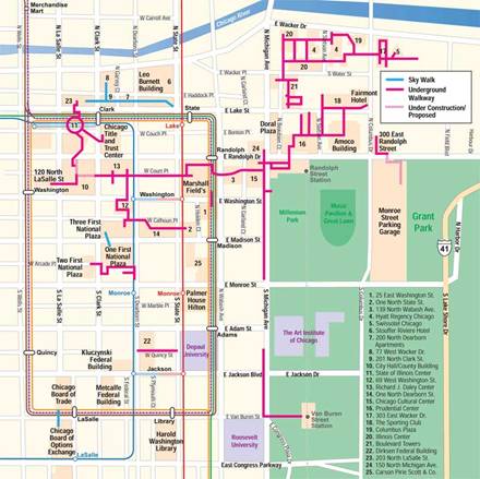
Chicago has an extensive pedway system.
References And Resources For More Information
Mark Byrnes (2012), “The Uncertain Legacy of America's Pedestrian Malls,” Atlantic Cities (www.theatlanticcities.com); at www.theatlanticcities.com/neighborhoods/2012/05/uncertain-legacy-americas-pedestrian-malls/1929
Ahmed El-Geneidy, Lisa Kastelberger and Hatem T. Abdelhamid (2011), Montréal’s Roots: Exploring the Growth of Montréal’s Indoor City, Journal of Transport and Land Use, Vol. 4, No. 2, Summer, pp. 33-46; at www.jtlu.org/index.php/jtlu/article/view/176/176.
Scott McKeen (2007), “Pedways Killing Street Ambience: If You Want A Vibrant City, Just Get Outside,” The Edmonton Journal, 28 December 2007; at www.canada.com/edmontonjournal/columnists/story.html?id=21c01ab7-c819-44a2-8a9e-967fb29c7ac2.
Wikipedia (2008), Pedways, Wikipedia (http://en.wikipedia.org/wiki/Pedway).
This Encyclopedia is produced by the Victoria Transport Policy Institute to help improve understanding of Transportation Demand Management. It is an ongoing project. Please send us your comments and suggestions for improvement.
Victoria Transport Policy Institute
www.vtpi.org info@vtpi.org
1250 Rudlin Street, Victoria, BC, V8V 3R7, CANADA
Phone & Fax 250-360-1560
“Efficiency - Equity - Clarity”
#128