Sense of Place
Create Paradise Where You Are
~~~~~~~~~~~~~~
Victoria Transport Policy Institute
~~~~~~~~~~~~~~~~~~~~
Updated 25 August 2016
This chapter discusses the importance of valuing a particular district or neighborhood as part of the process of creating more accessible and multi-modal communities.
Description
A Sense of Place is a general term for the recognition that every community and landscape is unique and deserves to be treated with. Community planning is sometimes called placemaking.
A Sense of Place means that people care about a community or landscape, and that policy and planning decisions reflect their concerns. When people work to improve their existing community or protect a unique landscape feature, they are showing a Sense of Place.
A Sense of Place means that people care about the communities and landscapes where they live and visit.
A Sense of Place is best illustrated by comparing it with its opposite, that is, treating communities and landscapes as generic commodities which should be bought and sold without concern of their non-market value, and which, if damaged, can be replaced. This is reflected in various market behaviors. For example, when people or businesses move to a new community because their existing neighborhood is getting run down, they are treating “place” as a commodity. Similarly, when residents are unwilling to support funding to rehabilitate their own community, in order to have money for holiday trips to exotic locations, they show a lack of Sense of Place.
A Sense of Place does not preclude suburban development or foreign holidays, however it reflects an incremental shift in priorities in favor of existing communities and non-market values. It means, that it may be rational for individuals and governments to forego possible financial income for the sake of non-market values. For example, it means that a worker may choose to give up a career advancement opportunity in order to stay in their current community, and that public may protect traditional landscapes, such as farming and wilderness, although it is not justified by direct economic benefits.
A Sense of Place means that people care about their local history, culture and community. It supports historic preservations, community redevelopment and social interaction. A Sense of Place has various implications for transportation policy and planning.
Increasing the Sense of Place and investing in Placemaking tends to support the development of more accessible communities with multi-modal transportation systems. A Sense of Place means that people place a greater value of Community Livability. This often involves tradeoffs between Mobility and Accessibility. Without a Sense of Place, it makes sense to accommodate ever increasing automobile travel, even if this degrades existing communities, with wider roadways and an increasing portion of land devoted to parking facilities. A Sense of Place justifies more efforts to protect and enhance existing neighborhoods, even if that requires constraining vehicle traffic.
Complete Streets, New Urbanism and Smart Growth apply various planning tools and transportation policies to enhance existing communities and protect landscapes. Transit Oriented Development is often used as a community redevelopment tools, reflecting a Sense of Place.
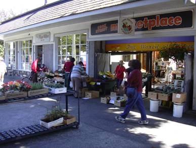
Walkability is particularly important for people who have a Sense of Place. Walking provides an opportunity for people to experience their community, and is a way for neighbors living in a community to meet and interact. Walking is also a critical form of local transportation, alone and in conjunction with Transit travel, which imposes minimal external costs, and therefore protects community Livability. It increases emphasis on the public realm, that is, spaces where people can interact, including roads, sidewalks, parks and other public facilities. This may mean, for example, that residents accept smaller private yards knowing that local parks are abundant, pleasant and safe to use.
A Sense of Place places more emphasis on brownfield reclamation and greenspace preservation (Land Evaluation). This improves existing communities, rather than degrading currently undeveloped lands, and by increasing development within existing urban areas, helps support more multi-modal transportation systems, rather than creating more automobile-dependent development at the urban fringe.
A Sense of Place means that residents invest personally in their community, for example, spending vacation time in their community and in nearby areas, investing their own money, and supporting additional public investments, when necessary, to protect and improve conditions.
One factor that deserves special consideration is the idea of aging in place, which means that people continue to live in their home or their community as they grow older. This is an increasingly important planning issue in many countries as the baby boom ages. “Place as commodity” implies that, once retired, consumers should be happy to move to a segregated community for the elderly, but A Sense of Place implies that there are special values to remaining in a family home and staying in a community where they have friends and family. In recent years many magazine articles and books have advised consumers on the architectural design features that make a home suitable for aging in place, for example, floor plans that accommodate wheelchair use, and appliances for people that can be used by people who are frail. Some also include mother-in-law suites intended to accommodate elderly relatives within a household. However, few discuss what may one of the most important factors to consider, neighborhood walkability and the quality of accessibility for non-drivers.
|
When locating a new building or other facility, many people choose the most attractive location available, although this usually spoils the features that made the site attractive. They then name the new development after the landscape features that were destroyed: “Fox Run Estates” is located where foxes no longer run, and “Green Valley Mall” covers a valley’s farms and forests with pavement.
As a general planning principle, it is better to build on the most unattractive location, because in this way the new construction improves on what currently exists. This means rebuilding run-down buildings, and redeveloping run-down neighborhoods. |
References And Resources For More Information
Christopher Alexander, et al (1977), A Pattern Language, Oxford University Press (www.oup.co.uk).
Donald Appleyard (1981), Livable Streets, University of California Press.
Charles C. Bohl (2002), Place Making: Developing Town Centers, Main Streets and Urban Villages, Urban Land Institute (www.uli.org).
Stephen Burrington & Veronika Thiebach (1995), Take Back Your Streets; How to Protect Communities from Asphalt and Traffic, Conservation Law Foundation (www.clf.org).
Julie Campoli and Alex MacLean (2002), Visualing Density: A Catalog Illustrating the Density of Residential Neighborhoods, Lincoln Institute of Land Policy (www.lincolninst.edu).
Center of Excellence for Sustainable Development (www.sustainable.doe.gov) is a US Department of Energy program that supports more resource efficient development.
Center for Livable Communities (www.lgc.org/clc) helps local governments and community leaders be proactive in their land use and transportation planning.
Center for Urban Transportation Research (http://cutr.eng.usf.edu) provides TDM materials and classes, and publishes TMA Clearinghouse Quarterly.
The Citizen Planner Institute (www.citizenplanner.com) trains average citizens, public officials, business people, and kids in the basics of neighborhood and town design.
CIVITAS (www.civitas-initiative.org) is a European Commission supported initiative to help introduce sustainable urban transport strategies.
CONCERN (2002), Placemaking Tools For Community Action: Tools That Engage The Community To Create A Future That Works For Everyone, Environmental Simulation Center
Denver Regional Office of the U.S. Department of Energy, U.S. Department of Housing and Urban Development, (www.sustainable.org/Placemaking_v1.pdf).
Congress for the New Urbanism (www.cnu.org), provides a variety of information on innovative urban design. The CNU Narrow Streets Database (www.sonic.net/abcaia/narrow.htm) describes more flexible zoning codes being implemented in various communities.
Cyburbia (www.cyburbia.org) is an Internet portal site for urban planners and others interested in cities and the built environment, maintained by the School of Architecture and Planning at the University of Buffalo.
DTLR (2001), Better Places to Live, U.K. Department for Transport, Local Government and the Regions (www.planning.dtlr.gov.uk/betrplac/index.htm) and the Commission for Architecture and the Built Environment (www.cabe.org.uk). This report examines attributes that underlie successful residential environments.
Andres Duany, Elizabeth Plater-Zyberk and Jeff Speck (2000), Suburban Nation: The Rise of Sprawl and the Decline of the American Dream, North Point Press (www.fsgbooks.com).
Alan Durning (1996), The Car and the City, Northwest Environment Watch (www.northwestwatch.org).
David Engwicht (1999), Street Reclaiming; Creating Livable Streets and Vibrant Communities, New Society Publishers (www.newsociety.com).
GQGP (2003), Smart Growth Audit Tool, Georgia Quality Growth Partnership (www.georgiaqualitygrowth.com). Identifies best practices for Smart Growth zoning codes and development requirements.
Great Streets (www.greatstreets.org) is an Internet site that provides information on urban design issues.
JTC (2003), Sustainable Urban Landscapes: Site Design Manual, James Taylor Chair, Landscape Architecture Program, University of British Columbia, (www.sustainable-communities.agsci.ubc.ca/projects/DesignManual.html).
James Kunstler (1993), The Geography of Nowhere, Simon & Schuster, (NY).
Suzanne Corwhurst Lennard & Henry Lennard (1995), Livable Cities Observed, Gondolier (Carmel).
LGC (2004), Creating Great Neighborhoods: Density in Your Community, Local Government Commission (www.lgc.org), US Environmental Protection Agency and the National Association of Realtors; available at www.lgc.org/freepub/PDF/Land_Use/reports/density_manual.pdf.
Todd Litman (2003), Evaluating Criticism of Smart Growth, VTPI (www.vtpi.org).
Todd Litman (2006), Community Cohesion As A Transport Planning Objective, Victoria Transport Policy Institute (www.vtpi.org/tca); available at www.vtpi.org/cohesion.pdf.
Living Streets (www.livingstreets.org.uk) (previously the Pedestrians Association) campaigns for urban redevelopment and pedestrian welfare. It provides a variety of information on ways of making streets and urban neighborhoods more livable.
William Lucy and David L. Phillips (2006), Tomorrow’s Cities, Tomorrow’s Suburbs, Planners Press (www.planning.org).
NAHB (various years), Smart Growth Case Studies, National Association of Home Builders (www.nahb.org).
Nelson\Nygaard (2009), Abu Dhabi Urban Street Design Manual, Abu Dhabi Urban Planning Council (http://www.upc.gov.ae/en/Home.aspx); at http://nelsonnygaard.com/Documents/Reports/Abu-Dhabi-StreetDesignManual.pdf.
New Colonist (www.newcolonist.com), a web magazine about urban living, provides information on New Urbanist and Smart Growth issues.
NewUrbanism.Org (www.newurbanism.org) provides a variety of information on New Urbanism.
Otak Inc. (1999), Infill and Redevelopment Code Handbook, Transportation and Growth Management Program, Oregon DOT and Dept. of Environmental Quality (www.lcd.state.or.us/tgm/publications.htm), 1999.
Project for Public Spaces (www.pps.org) works to create and sustain public places that build communities. It provides a variety of resources for developing more livable communities.
Reconnecting America (www.reconnectingamerica.org) is a national organization that works to coordinate transportation networks and the communities they serve
Harrison Bright Rue (2000), Real Towns: Making Your Neighborhood Work, Local Government Commission (www.lgc.org) and Citizen Planner Institute (www.citizenplanner.com).
San Francisco Planning and Urban Research Association (www.spur.org) is an organization working to improve urban planning practices in the San Francisco region.
Marc Schlossberg, John Rowell, Dave Amos and Kelly Sanford (2013), Rethinking Streets: An Evidence-Based Guide to 25 Complete Street Transformations, University of Oregon's Sustainable Cities Initiative (http://sci.uoregon.edu); at www.rethinkingstreets.com.
SFLCV (2003), This View of Density Calculator, San Francisco League of Conservation Voters (www.sflcv.org/density). This website illustrates various land use patterns, predicts their effects on travel behavior, and discusses various issues related to New Urbanist development.
The Smart Code (www.smartcode.org) is a planning implementation tool based on Smart Growth principles.
The Smart Growth Network (www.smartgrowth.org) includes planners, govt. officials, lenders, community developers, architects, environmentalists and activists.
Transport Geography on the Web (www.people.hofstra.edu/geotrans) is an Internet resource to promote access to transport geography information, including articles, maps, figures, and datatsets.
Urban Land Institute (www.uli.org) is a professional organization for developers that provides practical information on innovative development practices, including infill and sustainable community planning.
Urban Renaissance Institute (www.urban-renaissance.org) works to help cities and their regions flourish by applying innovative market-based policies.
USEPA, Smart Growth Policy Database, US Environmental Protection Agency (http://cfpub.epa.gov/sgpdb/browse.cfm) provides information on dozens of policies that encourage more efficient transportation and land use patterns, with hundreds of case studies.
Walkable Communities (www.walkable.org) helps create people-oriented environments.
This Encyclopedia is produced by the Victoria Transport Policy Institute to help improve understanding of Transportation Demand Management. It is an ongoing project. Please send us your comments and suggestions for improvement.
Victoria Transport Policy Institute
www.vtpi.org info@vtpi.org
1250 Rudlin Street, Victoria, BC, V8V 3R7, CANADA
Phone & Fax 250-360-1560
#98