Streetscape Improvements
Enhancing Urban Roadway Design
~~~~~~~~~~~~~~
Victoria Transport Policy Institute
~~~~~~~~~~~~~~~~~~~~
Updated 28 August 2018
This chapter discusses various ways to improve urban streetscapes to support more multi-modal transportation and create more attractive and accessible communities.
Description
Streetscape refers to urban roadway design and conditions as they impact street users and nearby residents. Streetscaping recognizes that streets are places where people engage in various activities, including but not limited to motor vehicle travel. Streetscapes are an important component of the public realm (public spaces where people interact), which help defines a community’s aesthetic quality, identity, economic activity, health, social cohesion and opportunity, not just its mobility.
Streetscaping (programs to improve streetscape conditions) can include changes to the road cross section, traffic management, sidewalk conditions, landscaping (particularly tree cover), street furniture (utility poles, benches, garbage cans, etc.), building fronts, and materials specifications. It also involves improving signage (AIGA 2005; Muhlhausen 2005).
Complete streets refers to roadway design and operating practices intended to safely accommodate diverse users and activities including pedestrians, cyclists, motorists, public transport users, people with disabilities, plus adjacent businesses and residents. Complete streets planning recognizes that roadways often serve diverse functions including through travel, recreational walking, socializing, vending, and nearby living, which must be considered and balanced in roadway design and management.
Streetscape can have a significant effect on how people perceive and interact with their community. If streetscapes are safe and inviting to pedestrians, people are more likely to walk which can help reduce automobile traffic, improve public health, stimulate local economic activity, and attract residents and visitors to a community.
Urban roadways have diverse functions. Streets accommodate automobile, public transit traffic, bicycle and pedestrian traffic; provide access to adjacent buildings and other destinations; provide space for commercial and recreational activities; and function as linear parks. Streetscaping therefore must account for various impacts and balance various planning objectives.
There are several different types of roadways as described in the following table.
Table 1 Urban Roadway Types (based on LADPH 2011)
|
Street Type |
Description |
Comments |
|
Highway (freeway) |
Designed for travel between urban area with little or no access. |
Creates a barrier to cross traffic, particularly non-motorized travel. |
|
Boulevard* (conventionally arterials) |
Traverses and connects districts and cities; primary a longer distance route for all vehicles including transit |
Often has a planted median |
|
Avenue* (conventionally collectors) |
Traverses and connects districts, links streets with boulevards. For all vehicles including transit. |
May or may not have a median |
|
Street* (conventionally local streets) |
Serves neighborhood, connects to adjoining neighborhoods; serves local function for vehicles and transit |
Can include a wide range of designs, uses and users |
|
Shared streets (also called home zones) |
Residential neighborhood streets designed to allow mixing of pedestrians (including children playing games), cyclists, and low-speed motor vehicle traffic |
Designed for very low traffic speeds |
|
Alley/Lane |
Link between streets; allows access to garages |
Narrow and without sidewalks |
* May have segments with specialized functions and features such as a Main Street in a commercial area.
Streetscaping can help create more diverse transportation systems and more accessible communities by improving nonmotorized travel conditions, creating more attractive urban environments, and integrating special design features such as Pedestrian Improvements, Cycling Improvements, Traffic Calming, HOV Priority and Road Space Reallocation. Streetscaping is an important component of New Urbanism, Transit Oriented Development, and other efforts to redevelop urban areas. It often includes wider sidewalks, bicycle lanes, bus pullouts, and improved on-street parking design, and other Complete Streets design features.
Figure 1 Streetscape Improvement With Road Diet (Urbana, IL)
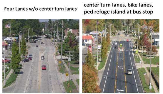
Before and after of a road diet on Philo Road in Urbana, Illinois which converted traffic lanes into turn lane, bike lanes, and added a crosswalk with pedestrian refuge island.
Figure 2 Sidewalk Improvements (Urbana, IL)

Before and after sidewalk expansion on Goodwin Avenue in Urbana, Illinois which accommodates more business and pedestrian activity.
In some situations it is possible to eliminate separated lanes and even sidewalks and share road space between various users (Hamilton-Baillie 2008), called shared streets, home zones or naked streets. This is appropriate on low- and medium-volume urban streets where vehicle traffic speeds are low.
|
Images of Past Streetscapes These films taken from urban trolleys provide a unique glimpse of urban streetscapes and activities in previous years.
1908 film of a trolley trip through Barcelona, Spain (www.flixxy.com/barcelona-spain-1908.htm).
Welcome to Victoria 1907, film of a trolley trip through downtown Victoria, BC (http://web.uvic.ca/lancenrd/AViewofVictoria/welcomepage/welcomepage.php)
1906 film of a trolley trip along Market Street in San Francisco (www.youtube.com/watch_popup?v=NINOxRxze9k).
1941 film of a trolley trip along Market Street in San Francisco (www.youtube.com/watch?v=wzqs6DF_wGE&p=6CBF7B2AE88DF1B4)
2005 film of a trolley trip along Market Street in San Francisco (www.youtube.com/watch?v=Vqcz_tllnwM&feature=related).
King of the Rails, 1915 General Electric (www.youtube.com/watch?v=ie5Ad3FLan0). |
How It Is Implemented
Streetscaping is often implemented as part of urban redevelopment efforts (New Urbanism) and Road Diets, which are arterial Traffic Calming projects (CTRE 2006; Knapp 2014; NJDOT 2012a and 2012b, Rosales 2006; NCCHPP 2013). It may be initiated by governments (EC 2009) or citizens and community groups (PPS 2008a). Ernst and Shoup (2009) recommend policy and planning reforms that support Streetscaping.
Such projects may be implemented on a single block, along a street, or for an entire district. Streetscape improvements can often be integrated as part of other roadway maintenance and building construction projects. For example, a community can establish design standards or guidelines that will be applied as part of scheduled construction work. Some streetscaping can be implemented as part of special programs, such as a parks program to plan trees along a roadway, or pedestrian facility improvements.
Streetscape improvements can also be incorporated into subdivision and roadway design standards, for example, by encouraging or requiring shorter blocks, wider sidewalks, bikelanes, narrower streets, landscaping, and other features that improve Accessibility, Walkability and aesthetics.
|
Protected Intersections (www.protectedintersection.com) Protected intersection is an intersection typology that encompasses a variety of design features to achieve safe, comfortable conditions for bicyclists and pedestrians. They can take a variety of configurations; however, all encourage slow turning by vehicles, good visibility for bicyclists and pedestrians, reduced pedestrian crossing distances, and the ability to make any turning movement by bicycle that maintains a feeling of security and priority that is absent in many current designs. Protected intersections creates complete intersections for Complete Streets. |
Streetscape improvements often require changing street design practices to allow Context Oriented Planning, such as narrower lanes (Isebrands, Newsome and Sullivan 2015). Streetscape improvements sometimes involve changing traffic flow patterns, particularly converting one-way into two-way streets. Analysis by Gilderbloom and Riggs (2015) in several U.S. cities indicates that such conversions:
· Reduce traffic speeds.
· Increase walking and cycling activity.
· Significantly reduce traffic accidents.
· Reduce local crime rates.
· Increase local business activity.
· Increase property values and tax revenues.
Streetscaping may be initiated by a community visioning or planning process which established guidelines for streetscape design. Implementation may involve special published guidelines, plans and funding for streetscape improvements on a particular street or in an area.
Streetscaping requires comprehensive Performance Indicators which reflect multiple modes and activities, including impacts on adjacent businesses and residents. The New York City Department of Transportation uses the following goals, strategies and performance indicators when evaluating city streets:
Table 2 New York City Street Performance Metrics (NYCDOT 2012)
|
Goals |
Strategies |
Metrics |
|
Safety Accommodate all users Create great public spaces |
Design safe streets Build great public spaces Improve bus service Reduce delay and speeding Efficiently manage parking and loading |
Motorist, pedestrian, and cyclist crashes and injuries Vehicle, bus passenger, bicycle rider, and public space user volumes Traffic volumes Travel speeds Traffic speeds (not too slow, but not too fast) Economic vitality (retail sales, building vacancies, visitors) Bus ridership and travel speeds User satisfaction Environmental and public health quality Double parking and parking duration |
New York City has established these goals, strategies and metrics for evaluating city street performance.
Travel Impacts
Travel impacts vary depending on the type of streetscape improvements. By itself, streetscaping tends to have modest impacts, but its effects may be large if implemented as part of an overall program to improve alternative modes (Nonmotorized and Transit) and encourage more Compact, infill development. Shade trees and improved Security may also encourage more walking. Traffic Calming and Road Space Reallocation can reduce automobile traffic volumes and speeds. Streetscaping that improves urban environments can support Smart Growth, which can result in more Diverse transportation systems and Accessible land use patterns.
Table 3 Travel Impact Summary
|
Objective |
Rating |
Comments |
|
Reduces total traffic. |
1 |
Improves walking & cycling conditions, and supports more compact development. |
|
Reduces peak period traffic. |
1 |
|
|
Shifts peak to off-peak periods. |
0 |
|
|
Shifts automobile travel to alternative modes. |
2 |
|
|
Improves access, reduces the need for travel. |
2 |
|
|
Increased ridesharing. |
0 |
|
|
Increased public transit. |
1 |
|
|
Increased cycling. |
1 |
|
|
Increased walking. |
2 |
|
|
Increased Telework. |
0 |
|
|
Reduced freight traffic. |
0 |
|
Rating from 3 (very beneficial) to –3 (very harmful). A 0 indicates no impact or mixed impacts.
Benefits and Costs
Streetscape Improvements can provide a variety of economic, social and environmental benefits.
· Improved Walking and Cycling conditions, and therefore increased nonmotorized travel.
· Increased traffic safety due to narrower streets and slower traffic (Traffic Calming).
· More compact, mixed, infill development (New Urbanism).
· Improved Community Livability, interaction and cohesion.
· Increased property values.
· Improved transport and access for non-drivers, and support Universal Design.
· Improved public Health due to increased walking and cycling.
Several studies indicate that common Streetscaping strategies, such as landscaping and narrowing traffic lanes, tend to increase traffic safety (Dumbaugh 2005). Research by the U.S. Highway Safety Research System (HSIS 2010) concludes that road diets (arterial street traffic calming) typically reduce crash rates by 47% on major highways through small urban areas, by 19% on corridors in larger city suburban areas, and 29% overall. Petritsch (2007) found that narrower traffic lanes tend to increase safety. The New York City Department of Transportation found that total crash rates (pedestrians, cyclists and motorists) decline 40-50% after bike lanes are installed on the city’s arterials (NYCDOT 2011). Marshall and Garrick (2011) conclude that more connected, multi-modal street design can significantly reduce traffic injury and fatality rates in U.S. cities. Stout, et al (2006) found that conversion of four-lane undivided roadways to three-lane cross-sections in typical Iowa towns reduced crash frequency by 25% and crash injuries by 34%. The table below summarizes crash reductions found in various Seattle area locations.
Table 4 Road Diet Crash Reduction Impacts (Seattle DOT)
|
Roadway Location |
Date Change |
ATD Before |
ADT After |
Collision Reduction |
|
Greenwood Ave N, N 80th St to N 50th |
April 1995
|
11,872 |
12,427 |
24 to 10 (58%)
|
|
N 45th Street, Wallingford Area |
December 1972 |
19,421 |
20,274 |
45 to 23 (49%)
|
|
8th Ave NW, Ballard Area |
January 1994 |
10,549 |
11,858 |
18 to 7 (61%)
|
|
Martin Luther King Jr Way, North of I 90 |
January 1994 |
12,336 |
13,161 |
15 to 6 (60%) |
|
Dexter Ave N, Queen Ann Area |
June 1991
|
13,606 |
14,949 |
19 to 16 (59%)
|
|
24th Ave NW, NW 85th to NW 65th |
October 1995 |
9,727 |
9,754 |
14 to 10 (28%)
|
This table summaries the crash reduction effects of road diets on major arterials in Seattle, Washington. (ATD = Average Daily Traffic)
Comparing various roadway designs, Riggs and Gilderbloomb (2017) find higher traffic collision and injury rates for motorists, bikes and pedestrians on one-way than comparable two-way counterparts, and one-way multi-lane streets contribute to degradation and erosion of community. The analysis indicates that neighbourhoods with one-way multilane streets experience greater abandonment, lower housing values and slower increases in property values.
Mohan, Bangdiwala and Villaveces (2017) analyzed the road networks and traffic crash fatality data in 16 randomly selected U.S. cities. They found that, more junctions per road length is significantly associated with a lower motor-vehicle crash and pedestrian mortality rates, and increased road kilometers of any kind is associated with higher fatality rates, with particularly large increases associated with more arterial highway and arterial road kilometers. The San Francisco Department of Public Health developed an Vehicle-Pedestrian Injury Collision Model which predicts how demographic, geographic and land use planning factors affect the number of collisions resulting in pedestrian injury or death in an area (SFDPH 2008a). The model indicates that pedestrian injuries and deaths increase with motor vehicle traffic volume, vehicle traffic speeds, pedestrian volume, and various intersection and street design factors.
By creating more attractive street environments, Streetscaping can support Economic Development, including increased retail activity, property development, land values and tax revenues (Fleming, Turner and Tarjomi 2013). For example:
· Retail sales increased 71% on Fordham Road in the Bronx following the introduction of more reliable Select Bus Service in 2008, three times the borough-wide growth rate.
· Retail sales increased as much as 49% on portions of Ninth Avenue in Manhattan after the installation of parking-protected bike lanes, or 16 times the borough-wide retail sales growth.
· In Brooklyn on the streets adjacent to Pearl Street Plaza, retail sales went up by 172%, nine times the borough-wide rate.
· Times Square retail rents doubled following the 2009 Green Light for Midtown project and new flagship stores have opened and which now generates $110 billion in economic activity. Times Square last year was listed for the first time as one of the top 10 retail locations on the planet.
· There were 49% fewer commercial vacancies in the Union Square North area, where new plazas, simplified intersections and a protected bike lane were installed, while there were 47% fewer commercial vacancies on First and Second Avenues after SBS and bike lanes were installed.
Urban trees can provide a variety of benefits, including reducing pollution, energy conservation (due to shade), improved public health, and increased property values (KIBI 2010). Naderi, Kweon and Maghela (2008) found that tree-lined streets are perceived to be safer in urban and suburban locations, and have lower average traffic speeds in suburban locations. Nixon, Weinstein Agrawal and Simons (2017) recommend methods for evaluating Streetscaping impacts.
Costs include the additional expenses associated with more detailed planning, design and amenities (sidewalks, transit, public spaces), and extra development costs associated with construction within existing urban areas (Bushell, et al. 2013).
Table 5 Benefit Summary
|
Objective |
Rating |
Comments |
|
Congestion Reduction |
1 |
Improves walking & cycling conditions, and supports more compact development. |
|
Road & Parking Savings |
1 |
|
|
Consumer Savings |
1 |
|
|
Transport Choice |
2 |
|
|
Road Safety |
2 |
Improves walking & cycling conditions and often includes traffic calming. |
|
Environmental Protection |
2 |
|
|
Efficient Land Use |
2 |
|
|
Community Livability |
3 |
|
Rating from 3 (very beneficial) to –3 (very harmful). A 0 indicates no impact or mixed impacts.
Equity Impacts
Streetscape improvement equity impacts vary depending on specific design features and conditions. They tend to improve walking and cycling conditions, and incorporate Universal Design features, and therefore improve mobility for people who are transportation disadvantaged (Bellefleur 2013).
Table 6 Equity Summary
|
Criteria |
Rating |
Comments |
|
Treats everybody equally. |
0 |
|
|
Individuals bear the costs they impose. |
0 |
|
|
Progressive with respect to income. |
1 |
Improves walking and cycling, and therefore pubic transit transport. |
|
Benefits transportation disadvantaged. |
2 |
" |
|
Improves basic mobility. |
2 |
" |
Rating from 3 (very beneficial) to –3 (very harmful). A 0 indicates no impact or mixed impacts.
Applications
Streetscape improvements tend to be applied most in urban areas and downtown areas where there are many pedestrians. Mitchell and Hamilton-Baillie (2011) describe applications in small towns and villages. They are generally implemented by local governments and developers.
Table 7 Application Summary
|
Geographic |
Rating |
Organization |
Rating |
|
Large urban region. |
2 |
Federal government. |
1 |
|
High-density, urban. |
3 |
State/provincial government. |
1 |
|
Medium-density, urban/suburban. |
2 |
Regional government. |
2 |
|
Town. |
2 |
Municipal/local government. |
3 |
|
Low-density, rural. |
1 |
Business Associations/TMA. |
3 |
|
Commercial center. |
3 |
Individual business. |
3 |
|
Residential neighborhood. |
2 |
Developer. |
3 |
|
Resort/recreation area. |
3 |
Neighborhood association. |
3 |
|
College/university communities. |
2 |
Campus. |
2 |
Ratings range from 0 (not appropriate) to 3 (very appropriate).
Category
Improves Transportation Options and Land Use
Relationships With Other TDM Strategies
Streetscape Improvements supports and is supported by Complete Streets, Traffic Calming, Pedestrian and Bicycle Improvements, Universal Design, Road Space Reallocation other urban redevelopment strategies, including New Urbanism, Smart Growth, Transit-Oriented Development, Context Sensitive Design, Location-Efficient Development, and Parking Management. It is one of the most effective TDM strategies for improving Community Livability.
Stakeholders
Streetscape improvements are generally implemented by local governments and developers. Neighborhood associations, business associations and developers are also important stakeholders with regard to many specific Streetscaping projects.
Barriers To Implementation
Existing zoning laws and development policies often discourage or prohibit Streetscape Improvements. There is sometimes local resistance to traffic calming and more compact development.
|
A man is feeling terrible. He can’t digest food, suffers from chest pains, and can’t think straight. The first doctor he visits performs a quick examination, and recommends various vitamin and mineral supplements. But the symptoms persist.
He goes to a second doctor who takes a medical history, and performs a careful examination. This doctor shakes his head sadly. The problem, he explains, is a weak heart that requires immediate surgery. The man endures the operation, but even after the incision heals the original symptoms persist.
He goes to a third doctor, who takes a detailed medical history, does a careful examination, and performs a series of expensive and painful tests. After the results are available, the doctor sits down with the man and gravely explains, the problem is a deadly and inoperable brain tumor – death is imminent.
Sadly, the man prepares for his demise. He purchases a plot at the cemetery. He selects a casket at the mortuary. Then he goes to a tailor for a new suit in which to be buried. The tailor measures him carefully, and then says, “I’ll make the pants 42 inches, the coat 38 inches, and the shirt neck 16 inches.”
“But,” the man replies, “I always wear 38 inch pants, a 34 inch coat and a 15 inch shirt neck.
“No! No! If I make 38 inch pants, a 34 inch coat and a 15 inch shirt neck you won’t be able to digest food, your chest will hurt, and blood flow to your brain will be constricted,” explains the tailor. |
Best Practices
The report Reclaiming City Streets For People: Chaos Or Quality Of Life? (EC 2009) provides guidelines for Road Space Reclaiming and Streetscaping.
· Planning should involve stakeholders.
· As much as possible, design every street to be a linear park, with wide sidewalks and other pedestrian amenities, landscaping, shade trees, street furniture, bike lanes, well-planned connections with public paths, attractive buildings, and other destinations.
· Use quality materials for street surfaces and furniture.
· Educate planners and developers about street design principles.
· Encourage cooperation between public and private decision makers to improve streetscapes.
· Foster “walkable” street designs.
|
Pedestrian Malls and Districts Pedestrianized commercial districts can support urban revitalization and economic development by creating a lively and friendly environment that attracts residents and visitors, although they must be carefully implemented to be effective (Rodriguez 2010; Tolley 2011). Some are closed to motor vehicle traffic altogether, at least during certain time periods such as evenings or weekends, while others allow automobile traffic but use traffic calming design strategies to control traffic speeds and volumes. Success varies depending on specific conditions. Many pedestrian-only commercial streets created in North American towns and cities during the 1970s failed to attract customers, and many were subsequently reopened to automobile travel, but others thrived, particularly in resort communities or as part of overall downtown redevelopment. Below are guidelines for creating successful pedestrianized streets and districts: · It is generally better to calm vehicle traffic and improve non-motorized conditions throughout an area, than to let high speed and volume motor vehicle traffic dominate except on a token pedestrian street. · Pedestrian areas require a critical mass of users. They should be both a destination and a thoroughfare that connects diverse attractions (housing, shops, offices, etc.). Encourage development that attracts a broad range of customers and clients, including retail, housing, education and employment. Apartments and offices can often be located over shops. · Develop a pleasant environment, with greenery, shade and amenities. Building features and street furniture should be pedestrian scale and attractive. Maintain high standards for security, cleanliness and physical maintenance. Minimize blank building walls. · Allow motor vehicles as required for access, with appropriate restrictions based on need, time and vehicle type. This may include unrestricted motor vehicle traffic during morning hours, transit vehicles, resident and hotel pickup, service and emergency vehicles, or other appropriate categories. · Pedestrian streets should be located in pedestrian-friendly areas with good access to public transit and parking. Slow and restrict vehicle traffic on cross-streets. · Develop a variety of artistic, cultural and recreational amenities (statues, fountains, playgrounds) and activities (concerts, fairs, markets). Highlight historical features.
Mark Byrnes (2012), “The Uncertain Legacy of America's Pedestrian Malls,” Atlantic Cities (www.theatlanticcities.com); at www.theatlanticcities.com/neighborhoods/2012/05/uncertain-legacy-americas-pedestrian-malls/1929.
Rodney Tolley (2011), Good For Busine$$ - The Benefits Of Making Streets More Walking And Cycling Friendly, Heart Foundation South Australia (www.heartfoundation.org.au); at https://heartfoundation.org.au/images/uploads/publications/Good-for-business.pdf. |
Examples and Case Studies
Context-Sensitive Roadway Design Standards (PennDOT & NJDOT 2008)
The Smart Transportation Guidebook provides specific recommended roadway design features (desired operating speeds, travel lanes, lane width, shoulder width, parking lane, bike lane, median, curb design, sidewalk width, and buffer between traffic and pedestrians) for different types of roadways (regional arterial, community arterial, community collector, neighborhood collector and local road) for various land use conditions (Rural, Suburban Neighborhood, Suburban Corridor, Suburban Center, Town/Village Neighborhood, Town/Village Center and Urban Core).
Ayd Mill Corridor Linear Park (www.aydmill.org):
Community groups in the St. Paul area have developed a proposal to streetscape the Ayd Mill Corridor so it functions as a linear park. The estimated cost is $1-$2/foot for 8,000 feet for each lane of Ayd Mill or $16,000-$32,000. This includes the following components:
- Stripe east two lanes of Ayd Mill Road for bicycle and pedestrian traffic. Safety of people is enhanced because the east lanes are physically separate from the car traffic in the west lanes, which have the access ramps.
- Set the maximum speed limit of the west side two car lanes of Ayd Mill Road to 35 miles per hour.
- Remove signs prohibiting use of Ayd Mill Road by pedestrians and non-motorized vehicles.
Shared Spaces
The Auckland Council, New Zealand promotes Shared Spaces which remove the distinction between footpath and traffic lanes, so vehicles and pedestrians can share roadspace. This is a useful strategy for many downtown commercial streets and some residential areas. Each street is assessed and the most appropriate design goes through a public consultation stage before works begin. The city conducted a detailed study on shared space performance. It found that:
- Peak hour foot traffic increased 50% (comparing pre-works in 2008 to post-works in 2011)
- There are noticeably fewer vehicles and they travel slower. Vehicle speeds declined more than 25%.
- 91% of stakeholders were highly complimentary about the new shared space, compared to 17% before.
- 75% of property owners determined that it was valuable being sited near or adjacent to a shared space.
- Almost half of those surveyed (49%) would visit the area more often, as a destination in its own right
NCDOT New Subdivision Guidelines (www.dot.state.nc.us/news/TNDsubdivguidelines00-08.html)
The N.C. Board of Transportation today approved Traditional Neighborhood Development (TND) Street Design Guidelines that will improve safety by promoting low speeds and cautious driving while fully accommodating the needs of pedestrians and bicyclists.
"By approving these guidelines, our Board of Transportation is to be commended for making smart transportation planning a priority," said Gov. Hunt. "These guidelines will improve the quality of life for all North Carolinians by helping us build strong communities across the state."
The alternative guidelines were developed in response to increased interest in balancing growth and quality of life initiatives and to promote neighborhood development. They were created in consultation with citizens, developers, builders, architects, engineers, planners, local government officials, state agencies and environmental organizations.
The following criteria are established in the new guidelines for TND developments:
· Streets will be designed to be only as wide as needed for low-speed traffic.
· Narrow streets are part of a dense transportation network that also includes sidewalks, walking paths and bike lanes.
· Sidewalks will line both sides of most neighborhood streets to encourage walking.
· On lower traffic volume streets, bicyclists should be considered a normal part of traffic. On higher volume streets, bicyclists should be accommodated with six-feet-wide bike lanes, but separate routes for less experienced bicyclists may be considered as well.
· On-street parking along major streets should have signs, markings or otherwise clearly be designated.
· Planting strips, located between the curb and sidewalk, help create shaded streets, promote walking and slow traffic.
· As a general rule, more and shorter street lights are preferred.
|
The Return Of The Two-Way Street: Why The Double-Yellow Stripe Is Making A Comeback In Downtowns. Alan Ehrenhalt, Governing Magazine, December 2009
Over the past couple of decades, Vancouver, Washington, has spent millions of dollars trying to revitalize its downtown, and especially the area around Main Street that used to be the primary commercial center. Vancouver has totally refurbished a downtown park, subsidized condos and apartment buildings overlooking it and built a new downtown Hilton hotel.
Some of these investments have been successful, but they did next to nothing for Main Street itself. Through most of this decade, the street remained about as dreary as ever. Then, a year ago, the city council tried a new strategy. Rather than wait for the $14 million more in state and federal money it was planning to spend on projects on and around Main Street, it opted for something much simpler. It painted yellow lines in the middle of the road, took down some signs and put up others, and installed some new traffic lights. In other words, it took a one-way street and opened it up to two-way traffic.
The merchants on Main Street had high hopes for this change. But none of them were prepared for what actually happened following the changeover on November 16, 2008. In the midst of a severe recession, Main Street in Vancouver seemed to come back to life almost overnight. Within a few weeks, the entire business community was celebrating. “We have twice as many people going by as they did before,” one of the employees at an antique store told a local reporter. The chairman of the Vancouver Downtown Association, Lee Coulthard, sounded more excited than almost anyone else. “It’s like, wow,” he exclaimed, “why did it take us so long to figure this out?”
A year later, the success of the project is even more apparent. Twice as many cars drive down Main Street every day, without traffic jams or serious congestion. The merchants are still happy. “One-way streets should not be allowed in prime downtown retail areas,” says Rebecca Ocken, executive director of Vancouver’s Downtown Association. “We’ve proven that.”
The debate over one-way versus two-way streets has been going on for more than half a century now in American cities, and it is far from resolved even yet. But the evidence seems to suggest that the two-way side is winning. A growing number of cities, including big ones such as Minneapolis, Louisville and Oklahoma City, have converted the traffic flow of major streets to two-way or laid out plans to do so. There has been virtually no movement in the other direction.
Anyone who travels a lot to the center of big cities has had an experience like this: You arrive at night, and start looking for your hotel. You find it, but you can’t drive to the entrance because the street is one-way the other way. Finally you come to a street that goes the way you want, but once you get close again, the signs won’t allow you to make the turn you need to make. You can waste 20 minutes this way. And as you keep driving, you notice that the streets are empty anyway. Any reason that might have existed for turning them into single-purpose speedways simply did not apply anymore.
Meanwhile, local governments were slowly learning that the old two-way streets, whatever the occasional frustration, had real advantages in fostering urban life. Traffic moved at a more modest pace, and there was usually a row of cars parked by the curb to serve as a buffer between pedestrians and moving vehicles. If you have trouble perceiving the difference, try asking yourself this question: How many successful sidewalk cafés have you ever encountered on a four-lane, one-way street with cars rushing by at 50 miles per hour? My guess is, very few indeed. So over the past 10 years, dozens of cities have reconfigured one-way streets into two-way streets as a means of bringing their downtowns to life. The political leadership and the local business community usually join forces in favor of doing this. There are always arguments against it. Some of them are worth stopping to consider.
Among the critics are traffic engineers and academics who were taught some fixed principles of transportation in school decades ago and have never bothered to reconsider them. Joseph Dumas, a professor at the University of Tennessee, argued a few years ago that “the primary purpose of roads is to move traffic efficiently and safely, not to encourage or discourage business or rebuild parts of town . . . . Streets are tools for traffic engineering.”
If you agree that streets serve no other purpose than to move automobiles, you are unlikely to see much problem with making them one-way. On the other hand, if you think that streets possess the capacity to enhance the quality of urban life, you will probably consider the Dumas Doctrine to be nonsense. That is the way more and more cities are coming to feel.
There are other arguments. It’s sometimes said that more accidents occur on two-way streets than one-way streets. The research that supports this claim is decades old, and to my knowledge, has not been replicated. Even if you accept this argument, though, you might want to consider that, at slower speeds, the accidents on two-way streets are much more likely to be fender-benders at left-turn intersections, not harrowing high-speed crashes involving cars and pedestrians.
Finally, there are complaints from fire departments that it takes them longer to reach the scene of trouble when they have to thread their way around oncoming traffic, rather than taking a straight shot down a one-way speedway. I can’t refute this, and in any case, I don’t like arguing with fire departments. But I have to wonder how many people have died in burning buildings in recent years because a fire truck wasn’t allowed to use a one-way street.
I wouldn’t argue that two-way streets are any sort of panacea for urban revival, Vancouver’s experience notwithstanding. And I understand that they are not always practical. Some streets simply are too narrow to have traffic moving in both directions; others have to be designated one-way because their purpose is to feed traffic onto expressways.
What I would say is this: When it comes to designing or retrofitting streets, the burden of proof shouldn’t fall on those who want to use them the old-fashioned way. It should be on those who think the speedway ideology of the 1950s serves much of a purpose half a century later.
Also see, John Gilderbloom and William Riggs (2015), Two-Ways to Fix Our Downtown Neighborhoods, presented at the International Urban Affairs Association Conference, 9 April, Miami, Florida (http://sun.louisville.edu/pdfs/love%20is%20a%20two-way%20street.pdf); summarized in www.planetizen.com/node/75629/two-ways-fix-our-neighborhoods. |
Village Transport Management (Mitchell and Hamilton-Baillie 2011)
The report, Traffic in Villages – Safety and Civility for Rural Roads: A Toolkit for Communities, describes ways to implement the Rural Roads Protocol, a set of principles for the management and maintenance of rural highways. These include:
- Understanding and exploiting the quality and character of the built and natural environment to increase driver awareness and to influence driver behaviour.
- Avoiding the imposition of standardised highway measures that can erode the distinctiveness and quality of villages, and serve to isolate drivers from their surroundings. Signs, road markings, barriers and traffic signals are kept to a minimum to reduce roadside clutter, and to engage drivers with the environment outside their car.
- Employing the principles of “psychological traffic calming” to influence driver speeds and responses. “Self-reading” roads that inform drivers appear to reduce speeds and improve drivers’ awareness of their surroundings by increasing interest and changing perceptions of time. Research suggests that the more our brains engage with interpreting the immediate environment, the less we sense time passing. This seems in turn to promote lower speeds and a reduced sense of urgency.
- Expanding the menu of measures available to local communities and local highway authorities beyond standardised highway measures. Such measures are intended to build on the principles of “place-making”, to make villages more distinctive and recognisable, introducing elements of intrigue, uncertainty and interest to alert drivers to the specific context of their surroundings.
- Redefining the boundaries for responsibility and management of village streets and spaces.
The report includes checklists of design strategies, and case studies of various British villages that have implemented streetscaping and traffic management programs. It is one of a series of documents which provide guidance for better addressing urban and rural traffic problems.
Main Street…When a Highway Runs Through It (DEA & Associates, 1999)
Many communities have main streets (streets that are major commercial centers) that also serve as a major arterials or highway. This requires streetscape planning and management that balances the needs of local users (pedestrians, shoppers, employees, business owners, and residents) with the needs of through traffic (both auto and freight) to move safely and efficiently over longer distances.
The State of Oregon produced a handbook titled Main Street…When a Highway Runs Through It, which offers guidance for communities to address these issues. It describes the many tools available to identify the problems and develop effective solutions for main streets that also serve as highways. As a complement to the Oregon Highway Design Manual, this handbook seeks to bring peaceful coexistence to the dual personas of downtown and highway. It proposes ways to design our main streets that make use of our natural inclination to drive as quickly or slowly as the roadway itself suggests. Its goal is to make main street a place that is attractive and that works from many points of view: pedestrian safety and activity, smooth traffic flow, economic vigor, and high quality of life.
|
An Urban Success Story: Octavia Boulevard An Asset To Post-Central Freeway Area By John King, San Francisco Chronicle, 3 January 2007 (http://sfgate.com/cgi-bin/article.cgi?file=/c/a/2007/01/03/BAG4VNBUJM1.DTL)
In the 15 months since it opened, San Francisco's Octavia Boulevard has been hailed as a model for other cities. It has been honored at the local and national level, including an award last month from the American Planning Association.
But here's the real measure of success: The thoroughfare that replaced the elevated Central Freeway feels like it belongs. It's not perfect, but it keeps cars moving while making the neighborhood around it a better place to be. That's exactly what was promised on 9 Sept. 2005, when politicians and community members gathered for a ribbon-cutting ceremony where Octavia Boulevard begins on the north side of Market Street, across from broad ramps leading to and from Highway 101.
The event was the culmination of a long battle to rid Hayes Valley of the Central Freeway, a double-deck structure that opened in 1959. The freeway connected western San Francisco to the center of the city -- but it split apart the neighborhood below, creating blight and a magnet for crime.
The fight began in earnest in 1996, when the freeway was closed temporarily to strengthen it against earthquakes. Three years and four competing ballot measures later, San Francisco's government and the California Department of Transportation agreed to build a ground-level thoroughfare instead. That campaign is what brought last month's recognition from the American Planning Association, which gave Octavia Boulevard the group's first "achievement award for hard-won victories."
It also cleared the way for the roadway that now exists, a short boulevard that draws on pre-freeway-era traffic engineering. At the most basic level, the boulevard connects the ramps that touch down at Market Street with Oak and Fell streets a few blocks to the north. Those roads serve as the main east-west link between downtown San Francisco and the neighborhoods around Golden Gate Park. But the idea is also to make the boulevard an urbane centerpiece to the blocks around it.
Commuters use Octavia's four central lanes, two in each direction, separated by low shrubs and elm trees. On either side of the commute lanes – buffered by poplar trees and more shrubs – is a "local lane" for neighborhood traffic, one heading north and one heading south.
The final touch, on the northern block: a neighborhood square with picnic tables and a play structure, two small lawns and a paved area reserved for temporary art installations. Any driver who relies on the boulevard can testify it's not a panacea. The morning commute often backs onto Oak Street; in the evenings, northbound lanes clog to the extent that impatient drivers often hop onto the local lane.
Part of the problem is unavoidable: American drivers expect throughways to be designed for convenience and speed. Octavia's openness may invite impatient drivers to accelerate -- though that openness will fade as trees mature and housing rises on empty lots created by the freeway demolition. The confusion also results from decisions at the city level.
For starters, the local lanes are too alluring. They're wider than what was proposed by planners Allan Jacobs and Elizabeth Macdonald, who designed the boulevard in collaboration with city staff led by the Department of Public Works; they also lack any sort of rough texture or wide bumps that would send a tactile signal to slow down. It's a change worth making as soon as budget allows.
Another problem is unavoidable: the location. This is a short boulevard that starts at San Francisco's central artery, Market Street. There are bans on making turns from Market onto the freeway on-ramp and from the boulevard onto Market, but logic dictates otherwise. No wonder there's confusion and frayed tempers.
But congestion doesn't mean the system is a failure. It means the boulevard is filling a need; a six-month study by the city's Department of Parking and Traffic found it attracts 45,000 vehicles on a typical weekday. And for whatever reason, slow-moving traffic is more irritating when you're on a city street than when you're on a freeway.
A better way to gauge the boulevard's success involves the condition of the landscaping and public spaces. In other words, are they as enticing after real-life wear as they were on opening day? The heartening answer is yes. Shrubs are filling in. Trees are spreading out. It's easy to imagine thick bands of greenery in five years that offer visual screens and a true sense of place. The small park has blossomed as well. You'll see people with dogs and people with cell phones, shoppers passing through and locals settled on a bench with coffee and friends. A street person can be napping on a bench while kids clamber on the play structure, and life goes on.
Even here, though, not everything is idyllic. The patch of green next to the play structure is a natural place for toddlers to let off steam – but some dog owners treat it as a track and bathroom for their pets. In other words, Octavia Boulevard could be better. There's congestion on the roadway and tension at the park. But in both cases, the problems are a result of popularity. They're heavily used. The larger picture is this: Things work. Hayes Valley has a gathering place. The landscape is well-maintained. Traffic continues to flow.
Octavia Boulevard began as a beguiling idea. Today, it's a promise fulfilled. In a city like San Francisco, that's progress -- the good kind. |
Crossroads Area Streetscape Plan (www.cupertino.org)
The City of Cupertino, California developed a streetscape plan for the Crossroads area to create an attractive, pedestrian-friendly shopping district at the town’s historic shopping core. The plan includes the following features:
· A 20-foot wide sidewalk with street furniture, pedestrian lighting and street trees along Stevens Creek Boulevard as new buildings are constructed or existing buildings are redeveloped.
· Buildings closer to the street and locate parking to the rear (for new construction).
· Active retail on the ground floor along Stevens Creek Boulevard.
· Decreased building heights from three to two stories to the rear of properties that are adjacent to single family residential zones, and allow more flexibility for building heights (an increase from 45 feet to 55 feet) in the front half of properties along Stevens Creek Boulevard for architectural features and pitched roofs.
Manual For Streets (www.manualforstreets.org.uk)
The Manual for Streets, published by the UK Department for Transport and Communities and Local Government, provides practical guidance for balancing multiple, often conflicting objectives in roadway planning and management. This document:
- Creates a new classification of roads which incorporates multi-functional streets such as 'main roads'.
- Uses a new hierarchy of users, which places pedestrians at the top.
- Proposes a new design process, designed to cater for engineering concerns about risk when adopting new design approaches.
- Summarizes research into the relationship between street geometry, speed and so road crashes.
- Summarizes extensive design guidance in one volume.
Economic Benefits of Street Design Improvements (CABE 2007)
A study by the UK Commission on Architecture and the Built Environment shows how good street design contributes both economic benefits and public value. It shows that investment in design quality brings quantifiable financial returns and that people value improvements to their streets. Ten London high streets were selected as case studies. The research shows that in London an achievable improvement in street design quality typically increase residential and commercial property values about 5%, reflecting the value that people place on an attractive street environment and the contribution it makes to local economic activity.
SoHo Streetscape (Schaller Consulting 2006)
A survey of more than 1,000 drivers and pedestrians traveling to a commercial street in central New York city found that most area shoppers do not drive, and that shifting street space from vehicle parking to pedestrians would increase the number of shoppers and the amount of business activity in the area. Shoppers who value wider sidewalks over parking spent about five times as much money, in the aggregate, as those who value parking over sidewalks. “The majority of shopping dollars, and the majority of residents and visitors that spend them, come by mass transit and on foot. The way we manage our street space should reflect this basic fact,” says Bruce Schaller, Principal of Schaller Consulting. “We already know that wider sidewalks are good for health, safety, and quality of life, now we know that they are also good for NYC's business,” says Paul Steely White, Executive Director of Transportation Alternatives.
Ninth Avenue Complete Street (www.dot.nyc.gov)
In the fall of 2007, the New York City Department of Transportation (NYCDOT) completely redesigned Ninth Avenue in Manhattan, part of a “complete street” design. The new design incorporates an innovative bicycle lane between the parking lane and sidewalk.
Major project elements included shortening the pedestrian crossing distance of this 70-foot-wide avenue and protecting the bicycle path from vehicular incursion, which has been an ongoing problem with traditional on-street bicycle lanes in Manhattan and which discourages cycling. To make the improvements quickly, the project was executed with operational measures rather than initiating a costly and time consuming capital construction project. The bicycle path in the project is separated from moving vehicles by an eight-foot buffer, a parking lane and from turning vehicles by discrete signal phases. At intersections, there are pedestrian refuge islands and turn bays where needed. The project uses pavement markings, signs, traffic signals and raised concrete islands to create a unique, safe and enjoyable street.
In preparation for the project, the project team reviewed studies and design treatments from abroad as well as our own work with bicycle facilities in New York. However, the team found no design that met our project goals and therefore developed an entirely new design for the project. Traditional bicycle lanes are located between the parking lane and travel lane of a roadway, where they are subject to violation by motor vehicles, but where visibility between motorists and cyclists is good. European cycle tracks are raised and therefore costly and difficult to build quickly. In order to move the bicycle lane between the parking lane and sidewalk, unique design treatments were developed to address the inherent loss of visibility and turning conflicts this type of configuration would create. A creative use of operational treatments allowed for quick and inexpensive installation.
Since the street grid of Manhattan consists of mostly one-way streets, there are only turning conflicts at every other intersection. At intersections where turns cross over the bicycle lane, we designed left-turn bays directly adjacent to the bicycle lane with protected left-turn phases to completely separate the conflicting through cyclist and left-turning motorist movements. Bicycle signal lenses are employed to regulate movement on the bicycle path.
The project has created a street that works for all of the users of the street, while responding to the limitations of existing bicycle facility design. In addition to creating a highly safe and enjoyable cycling environment, the project dramatically improved conditions for pedestrians, by narrowing the effective crossing distance of Ninth Avenue by almost 30 feet. Dedicated commercial loading space was also created for businesses on Ninth Avenue utilizing state-of-the-art multi-space parking meters. The aesthetic quality of the avenue is being further improved this spring when the pedestrian refuge islands created in the project will be planted with trees and shrubs by the Parks Department. Moreover, the project was achieved without creating additional traffic congestion.
To protect bicycle lanes from incursion by motor vehicles, the New York City cycling community, led by advocates and bicycle commuters, has appealed to NYCDOT to develop physically separated on-street bicycle facilities for close to a decade, often citing examples in northern and western European cities. The lack of a design for such a facility that could withstand the rigors of New York City’s streets has been an obstacle to implementing a physically separated bicycle lane in New York. However, the design piloted on Ninth Avenue has proven highly effective at addressing the problem of vehicular incursions while effectively mitigating the visibility and turning conflict problems.
Urban Street Design Guidelines (www.charmeck.org/Departments/Transportation/Urban+Street+Design+Guidelines.htm)
The City of Charlotte, North Carolina’s Urban Street Design Guidelines (USDG) are intended to create complete streets – streets that provide capacity and mobility for motorists, while also being safer and more comfortable for pedestrians, cyclists, and neighborhood residents. The USDG include information about why this new approach to planning and designing streets is necessary, how the guidelines should be applied, and how specific design features should be used for different types of streets. These guidelines have been applied to several projects in the City.
Individual USDG chapters are available below:
- Chapter 1 - Redefining Charlotte's Streets
- Chapter 2 - Designing Streets for Multiple Users
- Chapter 3 - Applying the Guidelines
- Chapter 4 - Segments
- Chapter 5 - Intersections
- Chapter 6 - Glossary
- Appendix A - Multimodal Level of Service at Signalized Intersections
- Appendix B - Pedestrian and Bicycle Level of Service at Signalized Intersections
- Appendix C - Curb Radii
New York City Street Design Manual (www.nyc.gov/html/dot/html/about/streetdesignmanual.shtml)
The New York City Street Design Manual provides policies and design guidelines to city agencies, design professionals, private developers and community groups for the improvement of streets and sidewalks. It is a comprehensive resource for promoting higher quality street designs and more efficient project implementation. The Manual builds on the experience of innovation in street design, materials and lighting that has developed around the world, emphasizing a balanced approach that gives equal weight to transportation, community and environmental goals. It is designed to be a flexible document that will change and grow, incorporating new treatments as appropriate after testing. Examples of applicable projects include capital and non-capital projects, such as street reconstructions and resurfacings; operational and traffic control treatments; street work associated with new or renovated buildings; and other public or private construction projects that include roadways, sidewalks, and plazas. Because cities are complex and diverse systems, street designs must be tailored for the particular needs and opportunities created by the local context, uses, and dimensions of streets. The Manual is intended to help:
· Set appropriate goals for each project
· Provide a framework for design decisions
· Establish a clear and consistent design review process
· Serve as a central, comprehensive reference guide
Multi-Modal Performance Evaluation
A key step toward more comprehensive and multi-modal transportation planning is the development of practical indicators of walking, cycling and public transit travel conditions, which can be used to identify potential problems and evaluate potential improvements. Below are specific examples of multi-modal performance indicators.
· The Transit Capacity and Quality of Service Manual (www.trb.org/main/blurbs/169437.aspx) provides guidance on Evaluating Public Transit service quality, including factors such as availability, frequency, travel speed, reliability, safety and security, price and affordability, network and system integration, comfort, accessibility, baggage capacity, universal design, user information, courtesy and attractiveness.
· The 2010 Highway Capacity Manual (the main reference guide for evaluating roadway system performance) created urban roadway LOS ratings for various modes, including walking, cycling, public transit and automobile (Dowling, et al. 2008; Elias and Parks 2013).
ú Cycling LOS takes into account the availability of parallel bicycle paths, the number of unsignalized intersections and driveways (because they create conflicts between cyclists and other vehicles), width of outside through lane or bicycle lane (the degree of separation between bicyclists and motor vehicle traffic), motor vehicle traffic volumes and speeds, portion of heavy vehicles (large trucks and buses), the presences of parallel parked cars, grades (hills), and special conflicts such as freeway off-ramps.
ú Pedestrian LOS takes into account pedestrian facility crowding, the presence of sidewalks and paths, vehicle traffic speeds and volumes, perceived separation between pedestrians and motor vehicle traffic (including barriers such as parked cars and trees), street crossing widths, extra walking required to reach crosswalks, average pedestrian crossing delay (time needed to wait for a gap in traffic or a crosswalk signal), and special conflicts such as multiple free right-turn lanes (which tend to be difficult for pedestrians to cross).
· WalkScore (www.walkscore.com) calculates the walkability of a location based on proximity to public services such as stores, schools and parks. However, it does not consider any other factors, such as the presence or quality of walking and cycling facilities (sidewalks, paths, crosswalks, etc.) or the ease of crossing streets (the presence of crosswalks, road widths, traffic volumes and speeds, etc.), or the quality of the pedestrian environment.
· The Walkability Checklist (www.walkableamerica.org/checklist-walkability.pdf), developed by the Partnership for a Walkable America and the Pedestrian and Bicycle Information Center, provides an easy-to-use form for evaluating neighborhood walkability, taking account factors such as the quality of sidewalks and paths, roadway crossing conditions (crosswalks, and traffic speeds and volumes), the degree of care by motorist, and amenities such as shade trees and street lighting along sidewalks, as perceive by users.
· The Bikeability Checklist (www.walkinginfo.org/cps/checklist.htm) developed by the Pedestrian and Bicycle Information Center includes ratings for road and off-road facilities, driver behavior, cyclist behavior, and barriers, and identifies ways to improve bicycling conditions.
· Neighborhood Bikeability Score (www.ibpi.usp.pdx.edu/neighborhoods.php) is a rating from 0 (worst) to 100 (best) that indicates the number of destinations (stores, schools, parks, etc.) that can be reached within a 20-minute bike ride, taking into account the quality of cycling infrastructure.
Complete Streets Gain Acceptance (www.usatoday.com/news/nation/2007-07-29-streetinside_N.htm)
Narrowed Roads Gain Acceptance In Colorado, Elsewhere
By John Ritter, USA Today
When Colorado Springs decided to make streets friendly to users other than cars, county officials howled. They threatened to withhold $3 million in transportation money if the city narrowed a street in front of county office buildings to add sidewalks and bike lanes.
The city went ahead and redesigned Tejon Street's traffic pattern under its "complete streets" program. It's part of a national trend that has dozens of state and local governments considering the needs of pedestrians, bike riders, seniors, the disabled and mass transit when they plan new roads or reconfigure existing ones.
Nearly a year later, the Tejon Street changes — its new "road diet" — have held up and the controversy has died, says city transportation manager Craig Blewitt. "A lot of people asked, 'Why are we reducing the number of lanes when the city has a congestion problem?' " he says. "Once this was talked through and explained, opponents decided to support it."
Proponents such as Louisville Mayor Jerry Abramson say complete streets policies make a city more livable and give residents options besides driving. Seniors who don't drive can walk safely and get to bus stops. A goal is to "calm" traffic on less busy streets. The concept even does its small part in the fight against obesity and global warming, proponents say, because it encourages exercise and reduces greenhouse gas emissions with fewer vehicle trips.
America's demographics are driving the complete streets movement, Abramson says. "The society is getting older. We're jogging, walking, bicycling much more than ever before," he says. Empty nesters leaving big suburban homes for downsized urban living want friendly, walkable streets, he says.
Critics such as David Hartgen, emeritus professor of transportation at the University of North Carolina-Charlotte, say pressure from interest groups such as senior advocates and bicycle organizations is forcing changes that can disrupt a road network beyond the stretches that have gotten a complete streets treatment. "It's really just arrogance and selfishness on the part of usually very small groups of individuals," Hartgen says. "They exert political power to 'take back the street,' but the street is not theirs to take back."
Sooner better than later
Even skeptics such as the League of California Cities concede that it's smarter and cheaper to design sidewalks, bike paths and transit amenities at the start of a project than to add them later. "The argument that persuaded Illinois legislators (to pass a complete streets bill last month) is that it's cheaper to do it right the first time," says Barbara McCann, coordinator of the National Complete Streets Coalition.
In Illinois, safety was also a focus of the debate over the bill awaiting the governor's signature. After a 17-year-old boy was killed in 2000 riding his bike across the only bridge over the Fox River outside Cary, his family won a wrongful death lawsuit against the state. Public pressure forced the state to add bike and pedestrian access to the bridge.
Complete streets designs usually take account of road types. Bike lanes and sidewalks aren't appropriate on freeways, for instance. When a city respects needs of the 50-plus residents in designing streets, "you absolutely make it livable for everybody else," says Elinor Ginzler, the AARP's livable communities director.
Complete streets make economic sense in Colorado, says Dan Grunig, executive director of the advocacy group Bicycle Colorado. A state study in 2000 found that 70% of the 700,000 visitors to mountain resorts who bicycled during their stays came from out of state and spent at least $141 million.
'A perfect storm of issues'
Cheri Harem, Chicago's acting transportation commissioner, says user-friendly streets are a priority of Mayor Richard Daley. "We decided to formalize the policy last year to make a stronger statement," Harem says. The public has bought into complete streets, she says, because the city won't modify a street without seeking community feedback.
Oregon's 1971 law requiring sidewalks and bike paths on most of the state's roads is considered the first major move toward complete streets. Over the years, creating bike access became popular in many parts of the country. But now state and local governments, like Chicago, are saying, in effect, let's consider all users every time we build or rebuild a road.
"There's an awakening because of a perfect storm of issues coming together," says Randy Neufeld, head of the Chicagoland Bicycle Federation. With growing concern over an obesity epidemic, cities see how streets, and the ability to be physically active on them, affects their health, he says. Rising gasoline prices, the push to cut greenhouse gas emissions and aging baby boomers who're getting out of their cars are all factors advancing the complete streets movement, Neufeld says.
Mark Leno, the California assemblyman who sponsored a bill that passed one chamber, cites estimates that if every resident of a city of 100,000 replaced one car trip with one walking or biking trip once a month, emissions of carbon dioxide, a key greenhouse gas, would be cut by nearly 4,000 tons a year. "So this tiny little consideration of accommodation of the roadway, this relatively simple act, has far-reaching implications," Leno says.
Traffic Calming Economic Development Benefits (Drennen 2003)
Traffic Calming can help improve retail environments and support local Economic Development. In a survey of business owners in an urban retail district, Drennen (2003) found that 65% consider a local Traffic Calming program to provide overall economic benefits, compared with 4% that consider it overall negative, and 65% support further traffic calming projects in their area. These benefits can be particularly important in tourist-oriented business districts, and as part of community revitalization. Drennen also argues that Traffic Calming can provide economic benefits by increasing use of alternative modes and reducing automobile expenditures, giving consumers more money to spend on locally produced goods. Drennen discusses the following potential economic impacts of traffic calming.
- Economic Revitalization and Property Values. Traffic calming can increase residential and commercial property values, which attracts wealthier residents to the area (gentrification) and can increase retail sales and bring economic revitalization to a commercial corridor.
- Attractiveness and Safety. Traffic calming creates more attractive environments, reduces auto speed, and increases safety for pedestrians, bicyclists, drivers, and other users of the street, which is good for business.
- Sales and Attracting Customers. Traffic calming encourages local residents to buy in their own neighborhoods, and also attracts customers from a wider area due to reduced travel time, hassle, and cost. Traffic calming can also help people live less car-dependent lifestyles, which will increase the amount of discretionary income they can spend on things other than transportation.
- Parking. Most businesses are concerned about the quality and quantity of customer parking and access for delivery trucks. However, too large a supply of subsidized, on-street parking can harm businesses.
- Impact on Employees. Poor bicycle, pedestrian, and transit conditions can harm businesses by losing worker productivity and time to gridlock, and by impairing employee recruitment. Conversely, improved transportation facilities can provide more convenience for employees.
- Construction and Costs. Traffic calming projects often require only minimal “down time” for construction, and most do not require any investment from business owners.
Roadway Design (Wei and Lovegrove 2010)
Compares the traffic safety impacts of various neighbourhood street patterns. Although all can provide comparable accessibility, the 3-way offset and fused grid patterns reduce accidents as much as 60% compared to grid and cul-de-sacs. These are considered lower-bound benefits because they do not include the additional safety benefits of auto to non-auto mode shifts. Before-and-after studies indicate that increasing bicycle use does not lead to a commensurate increase in bicycle collisions.
Bicycle Lane Impacts On Retail (Sztabinski 2009)
Shoppers who arrive walking, cycling or public transport tend to spend less per trip but make more trips per month and so spend more in total than automobile shoppers (Clifton, et al. 2012 and 2013). A study that examined the impacts of proposed bike lanes on retailers along Bloor Street in Toronto found that:
- Only 10% of patrons drive to stores, the rest arrive by walking, cycling or public transit.
- Even during peak periods no more than about 80% of metered parking spaces on the street are occupied.
- Patrons arriving by foot and bicycle visit the most often and spend the most money per month.
- More merchants who believe that a bike lane or widened sidewalk would increase business than merchants who think those changes would reduce business.
- Patrons would prefer a bike lane to widened sidewalks at a ratio of almost four to one.
- The reduction in on‐street parking supply from a bike lane or widened sidewalk could be accommodated in the area’s off‐street municipal parking lots.
This analysis indicates that in many situations, expanding sidewalks and converting bicycle and transit lanes, or wider sidewalks, could support local economic development.
Street Mobility Project (www.ucl.ac.uk/street-mobility)
University College London’s Street Mobility Project is a research program to develop practical tools for measuring community severance and overcoming barriers to walking by older people. It includes a Toolkit that gives local governments and communities ways to assess community severance.
Healthy Retailing (www.urbanfarmhub.org/2010/02/innovations-in-healthy-retail-pay-off)
Some communities are working to redevelop community retail streets to support local economic development and improve access to healthy food.
Brooklyn’s Storefront Facelift
In the Myrtle Avenue project in Brooklyn, New York, organizers worked with local economic development agencies to influence small retailers along 20 city blocks to beautify the street and develop a focused economic development strategy. Jennifer Stokes and Sarah Farwell described a “holistic approach” including graffiti removal, substituting see-through security gates for solid gates, additional lighting and upgraded store fronts. Before and after images from their Storefront Improvement Grants showed that an investment of less than $20,000 could make a huge difference in the appearance of the street and the sense of vibrancy and safety of the neighborhood. Surveys indicated what types of new businesses to recruit, such as a gym or bakery, to attract more people to the business district and improve sales for all.
San Jose Spruces Up Grocery Stores
In San Jose, California, Richard Keit, Director of Neighborhood and Business Development with the San Jose Redevelopment Agency, reported that they take a great interest in grocery stores. Their well-funded program includes: façade improvements using a menu of architect-developed design schemes, project management, tree planting, lighting and banners. Participating grocery stores have seen great increases in business when they update and open up their building façades, add plantings and remove or diminish the appearance of security bars. Sales tax revenue data also shows steady increase of business.
Urbane Development Builds Grocery Store Partnerships in Underserved Communities
Urbane Development advances local economic development strategies for health food retail with major municipal clients such as the cities of Detroit, Michigan, and Newark, New Jersey. To bring about improvements, CEO James Johnson-Piett accesses capital from federal, state, municipal sources, and financial intermediaries including community development banks. Health food retail projects range from discrete projects such as façade improvements, and geographic corridor improvements to comprehensive approaches that focus on all phases of “intervention” including technical assistance and financing.
Urbane Development is working with Detroit Economic Growth Corporation to address the lack of full service grocery stores in the city of Detroit by designing a comprehensive food retail attraction, retention and expansion program through dedicated grants, lines of credit, and varieties of technical assistance. Working with the Brick City Development Corporation in Newark, NJ, Urbane Development created a small grocery technical assistance and capacity building program to increase the availability of fresh, healthy foods to Newark residents. They also created a program of grants and loans for leasehold improvements, inventory and equipment costs, plus training in grocery operations and even design and construction support.
It Pays to Open Up a Grocery Store in Philadelphia
Brianna Sandoval of The Food Trust, based in Philadelphia, Pennsylvania, discussed the need for understanding the needs of food retailers. In the Fresh Food Financing Initiative, a $120 million funding pool created by public-private partnership provides incentives to operators to open shops in areas where they might not otherwise have done business. Businesses have to be located in low or moderate income census tracts and areas considered underserved based on size of businesses and proximity from other stores.
Converting Highways to Urban Streets
The report, The End of a Life Cycle: Urban Highways Offer Cities New Opportunities for Revitalization (www.itdp.org/urbanhighways) describes the trend in many cities to convert urban highways into multi-modal roadways, with slower speed, wider sidewalks, special lanes for bicycles and buses, and attractive streetscaping to integrate them into the urban environment. Examples are described in Portland, Oregon; San Francisco, California; Milwaukee, Wisconsin; Seoul, South Korea; and Bogotá, Colombia. These cities demonstrate the social, economic, and environmental benefits of removal or of reinvesting in other options and opportunities.
National Urban Street Design Guide (http://nacto.org/urbanstreetdesignguide-overview)
The National Association of City Transportation Officials (NACTO) Urban Street Design Guide describes the design principles and strategies that can be used to achieve diverse uses within and adjacent to public streets, including walking, cycling, public transit travel, parking, recreation, business activities and living. It is based on the fundamental idea that streets are spaces for people as well as vehicle traffic corridors. The guide provides specific recommendations.
Vision And Direction For London’s Streets And Roads (TFL 2012)
The City of London commissioned a Roads Task Force which established a vision and technical resources for designing and managing London’s streets to balance various goals, including enabling people and vehicles to move more efficiently on London’s streets and roads; transforming the environment for cycling, walking and public transport; and improving the public realm and provide better and safer places for all the activities that take place on the city’s streets, and provide an enhanced quality of life. To accomplish this it:
- Set priorities for different streets and roads, and make trade-offs accordingly
- Reflect changing functions and aspirations as streets and areas change
- Identify the tools that may be appropriate locally to deliver change
- Understand the need for intervention at a strategic level to keep London moving
Since it was published the Task Force has published updates which review progress.
Ciclovia and Recreovia (www.streetfilms.org/archives/ciclovia)
Every Sunday more than 70 miles of Bogota, Columbia streets are closed to motor vehicle traffic so residents can walk, bike, run, skate, recreate, picnic, and visit with family, neighbors & strangers. Nearly 1.8 million Colombians use the Ciclovia and Recreovia to de-stress, get healthy, and connect personally with their fellow citizens. Young or old, rich or poor, pedestrian or cyclist - in Bogotá everyone loves the Ciclovia. This program encourages share living, civility and urbanism.
Complete Streets Fact Sheets (www.completestreets.org/complete-streets-fundamentals/factsheets)
The National Complete Streets Coalition produces fact sheets on various streetscaping and complete streets issues:
- Children
- People with Disabilities
- Older Adults
- Health
- Public Transportation
- Climate Change
- Economic Revitalization
- Gas Prices
- Safety
- Lower Transportation Costs
- Ease Traffic Congestion
- Costs of Complete Streets
- Change Travel Patterns
- Create Livable Communities
- Sustainable Complete Streets
- Networks Complete Streets
Complete Streets Resource Toolkit (www.sacog.org/complete-streets/toolkit/start.html)
Complete Streets Resource Toolkit is a collection of valuable resources related to complete streets, and part of SACOG's complete streets technical assistance program. The toolkit is continually maintained and updated through user input. It includes the following sections:
- Access & Mobility
- Best Practices
- Bicycling
- Case Studies & Examples
- Context Sensitive Solutions
- Costs & Funding
- Data & Demographics
- Design
- Economics
- Education & Outreach
- Enforcement
- Engineering & Planning
- Fact Sheets
- Health And Safety
- Implementation
- Introduction To Complete Streets
- Kids & Safe Routes To School
- Land Use
- Liveable Communities
- Maintenance & Operations
- Pedestrians & Walkability
- Performance Measures
- Photo Simulations
- Policies & Legislation
- Presentations
- Roads & Cars
- Senior/Disabled
- Signals/Its
- Transit
Portland Guide for Public Street Improvements (www.portlandonline.com/auditor/index.cfm?c=27478).
The city of Portland, Oregon developed several information resources to help improve street design quality:
- Design Guide for Public Street Improvements, helps consulting engineers prepare construction drawings for public street improvements.
- Design Standards for Public Streets, describes national and local engineering standards for street elements and right-of-way widths, including the city of Portland’s Skinny Street Standards (adopted 1991), Pedestrian Design Guidelines of the Pedestrian Master Plan (adopted 1998), and Bicycle Master Plan (adopted 1996).
- Creating Public Streets and Pedestrian Connections through the Land Use and Building Permit Process, which incorporates existing street design standards and identifies other relevant design manuals. Where possible, information has been simplified for easier understanding, and it is presented based on zoning designations.
Measuring Streetscapes for Livability (Harvey 2014)
The report, Measuring Streetscape Design for Livability Using Spatial Data and Methods, includes two journal articles which describe practical methods for evaluating streetscape livability. It offers a method for identifying and cataloging roadway design factors that are considered to affect the appeal of streets, which are also practical to measure using widely available spatial data. This approach allows measurement of tens of thousands of street segments precisely and efficiently, a dramatically larger sample than can be feasibly collected using the existing auditing techniques of planners and researchers. The paper also examines clustering patterns among skeleton variables for street segments throughout Boston, New York, and Baltimore, identifying four streetscape skeleton types that describe a ranking of enclosure from surrounding buildings--upright, compact, porous, and open. The types are identifiable in all three cities, demonstrating regional consistency in streetscape design. Moreover, the types are poorly associated with roadway functional classifications--arterial, collector, and local--indicating that streetscapes are a distinct component of street design and must receive separate planning and design attention.
A second paper assesses relationships between these variables and crowdsourced judgments of streetscape visual appeal throughout New York City. Regression modeling indicates that streetscapes with greater tree canopy coverage, lined by a greater number of buildings, and with more upright cross-sections, are more visually appealing. Building and tree canopy geometry accounts for more than 40% of variability in perceived safety, which is used as an indicator of appeal. While unmeasured design details undoubtedly influence overall streetscape appeal, basic geometry may contribute important baseline conditions for appealing streetscapes that are enduring and can meet a broad variety of needs.
London Streetscape Guidance (TfL 2005)
The City of London has established guidelines for streetscaping that describe the type of pedestrian facilities, landscaping, materials, signage, street furniture and building design features that should be applied when possible. The program also includes significant funding for implementing streetscape improvements along specific roads.
References And Resources For More Information
AARP (2009), Planning Complete Streets for an Aging America, American Association for Retired Persons Public Policy Institute (www.aarp.org/ppi); at www.aarp.org/research/housing-mobility/transportation/2009_02_streets.html.
ADUPC (2009), Abu Dhabi Urban Street Design Manual, Abu Dhabi Urban Planning Council (www.upc.gov.ae/en/Home.aspx); at www.upc.gov.ae/guidelines/urban-street-design-manual.aspx?lang=en-US; and the Online Street Design Tool (https://usdm.upc.gov.ae/usdm_online_tool/USDM_Online_Tool.html).
ADUPC (2013), Abu Dhabi Public Realm Design Manual, Abu Dhabi Urban Planning Council (www.upc.gov.ae/en/Home.aspx); at www.upc.gov.ae/prdm/index.asp.
AIGA (2005), Symbol Signs, American Institute of Graphic Arts (www.aiga.org/content.cfm?ContentAlias=symbolsigns). Provides a list of 50 standard symbols for use in buildings, on streets, in transportation terminals, and other locations were people require wayfinding directions.
Olivier Bellefleur (2013), Urban Traffic Calming and Health Inequalities: Effects and Implications for Practice, National Collaborating Centre for Healthy Public Policy (www.ncchpp.ca); at www.ncchpp.ca/175/publications.ccnpps?id_article=917.
Dan Burden and Todd Litman (2011), “America Needs Complete Streets,” ITE Journal (www.ite.org), Vol. 81, No. 4, April, pp. 36-43; at www.vtpi.org/ITE_comp_st.pdf.
Max A. Bushell, Bryan W. Poole, Charles V. Zegeer and Daniel A. Rodriguez (2013), Costs for Pedestrian and Bicyclist Infrastructure Improvements: A Resource for Researchers, Engineers, Planners, and the General Public, Pedestrian and Bicycle Information Center (www.walkinginfo.org), Federal Highway Administration; at www.walkinginfo.org/download/PedBikeCosts.pdf.
CABE (2007), Paved with Gold: The Real Value of Street Design, Commission on Architecture and the Built Environment (www.cabe.org.uk); at www.cabe.org.uk/default.aspx?contentitemid=1956.
CALTRANS (2014), Main Street, California: A Guide for Improving Community and Transportation Vitality, California Department of Transportation (www.dot.ca.gov); at www.dot.ca.gov/hq/LandArch/mainstreet/main_street_3rd_edition.pdf.
CIVITAS (www.civitas-initiative.org) is a European Commission supported initiative to help introduce sustainable urban transport strategies.
City on the Move Institute (www.ville-en-mouvement.com/en) supports the development of the cultures of urban mobility and of civilities, with particular attention to streetscape design and management.
Kelly J. Clifton, et al. (2012), Consumer Behavior and Travel Mode Choices, Oregon Transportation Research and Education Consortium (www.otrec.us); at http://kellyjclifton.com/Research/EconImpactsofBicycling/OTRECReport-ConsBehavTravelChoices_Nov2012.pdf.
Kelly J. Clifton, et al. (2013), Examining Consumer Behavior and Travel Choices, Oregon Transportation Research and Education Consortium (www.otrec.us); at http://otrec.us/main/document.php?doc_id=1250.
Congress for the New Urbanism (www.cnu.org), provides a variety of information on innovative urban design. The CNU Narrow Streets Database (www.sonic.net/abcaia/narrow.htm) describes more flexible zoning codes being implemented in various communities.
Complete Streets (www.completestreets.org) is a campaign to promote roadway designs that effectively accommodate multiple modes and support local planning objectives.
CTRE (2006), Four-Lane to Three-Lane Conversion: Research Projects/Reports, Center for Transportation Research and Education (www.ctre.iastate.edu); at www.ctre.iastate.edu/research/4laneto3lane.htm.
DEA & Associates (1999), Main Street…When a Highway Runs Through It, Transportation and Growth Management Program, Oregon DOT and Dept. of Environmental Quality (www.lcd.state.or.us/tgm/publications.htm); at www.oregon.gov/lcd/tgm/docs/mainstreet.pdf.
DfT (2006), Manual for Streets, Department for Transport (www.manualforstreets.org.uk). Provides guidance to practitioners on effective street design.
DfT (2011), Shared Space, Local Transport Note 1/11, Department For Transport (www.dft.gov.uk); at http://assets.dft.gov.uk/publications/ltn/1-11.pdf.
Richard Dowling, et al. (2008), Multimodal Level Of Service Analysis For Urban Streets, NCHRP Report 616, Transportation Research Board (www.trb.org); at http://trb.org/news/blurb_detail.asp?id=9470; User Guide at http://onlinepubs.trb.org/onlinepubs/nchrp/nchrp_w128.pdf. This describes ways to evaluate roadway design impacts on various modes (walking, cycling, driving and public transit).
Dowling Associates (2010), CompleteStreetsLOS: Multi-Modal Level-of-Service Toolkit, Dowling Associates (www.dowlinginc.com/completestreetslos.php). This software program automates the procedures described in NCHRP Report 616, Multimodal Level of Service for Urban Streets, for evaluating complete streets, context-sensitive design alternatives, and smart growth from the perspective of all users of the street.
DPZ (2005), Smart Code; A Comprehensive Form Based Ordinance, The Town Paper (http://tndtownpaper.com). This model zoning code developed by Duany Plater-Zyberk promotes New Urban development by allowing more flexibility and innovation in building and street design.
Emily Drennen (2003), Economic Effects of Traffic Calming on Urban Small Businesses, Masters Thesis, San Francisco State University (www.emilydrennen.org); at www.emilydrennen.org/research_trans.shtml.
Eric Dumbaugh (2005), “Safe Streets, Livable Streets,” Journal of the American Planning Association (www.planning.org), Vol. 71, No. 3, pp. 283-300; at www.naturewithin.info/Roadside/TransSafety_JAPA.pdf.
EC (2009), Reclaiming City Streets For People: Chaos Or Quality Of Life?, European Commission Directorate-General For The Environment (www.ec.europa.eu/index_en.htm); at http://ec.europa.eu/environment/pubs/pdf/streets_people.pdf.
Debra Efroymson (2012), Moving Dangerously, Moving Pleasurably: Improving Walkability in Dhaka: Using a BRT Walkability Strategy to Make Dhaka’s Transportation Infrastructure Pedestrian-Friendly, Asian Development Bank (www.adb.org); at www.adb.org/sites/default/files/projdocs/2012/39335-012-reg-tacr-01.pdf.
Aaron Elias and Kamala Parks (2013), HCM Urban Streets Methodology: Bicyclist, Pedestrian, and Transit Passenger, TRB Webinar; at http://onlinepubs.trb.org/onlinepubs/webinars/131031.pdf.
Michelle Ernst and Lilly Shoup (2009), Dangerous by Design: Solving the Epidemic of Preventable Pedestrian Deaths (and Making Great Neighborhoods), Transport for America (http://t4america.org); at http://t4america.org/docs/dangerousbydesign/dangerous_by_design.pdf.
Reid Ewing and Steven Brown (2009), U.S. Traffic Calming Manual, Planners Press (www.planning.org) and ASCE Press (www.asce.org).
T. Fleming, S. Turner and L. Tarjomi (2013), Reallocation of Road Space, Research Report 530, NZ Transport Agency (www.nzta.govt.nz); at www.nzta.govt.nz/resources/research/reports/530/docs/RR-530-Reallocation-of-road-space.pdf.
Paul Fremer and Michael Stöckert (2016), Towards More Livable and Safer Cities: Examples for Safe Road Infrastructure Design, GIZ and Sustainable Urban Transport Program (http://sutp.org); at http://bit.ly/1TEB9Qj.
Gehl Architects (2013), Istanbul: An Accessable City – A City For People, EMBARQ Turkey (www.embarqturkiye.org); at www.embarq.org/research/publication/istanbul-public-spaces-and-public-life.
John Gilderbloom and William Riggs (2015), Two-Ways to Fix Our Downtown Neighborhoods, presented at the International Urban Affairs Association Conference, 9 April, Miami, Florida (http://sun.louisville.edu/pdfs/love%20is%20a%20two-way%20street.pdf); summarized in www.planetizen.com/node/75629/two-ways-fix-our-neighborhoods.
Joe Gilpin (2016), “Building Better Communities Through Complete Streets – The Protected Intersection,” ITE Journal, Vol. 86, No. 3, pp. 40-43; at https://mydigitalpublication.com/publication/?i=292025.
Global Designing Cities Initiative (http://globaldesigningcities.org), works to raise the state of practice of urban transport planning and roadway design in order to expand the uses and users served by public streets.
Greenroads (www.greenroads.us) describes a standard for quantifying sustainable practices associated with the design and construction of roads.
Ben Hamilton-Baillie (2008), “Toward Shared Space,” Urban Design International, Vol. 13, pp. 130–138; at www.hamilton-baillie.co.uk/_files/_publications/30-1.pdf. Related publications at Hamilton-Baillie Associates, www.hamilton-baillie.co.uk.
Chester Wollaeger Harvey (2014), Measuring Streetscape Design for Livability Using Spatial Data and Methods, Thesis, University of Vermont; at http://scholarworks.uvm.edu/graddis/268.
Douglas W. Harwood, et al. (2007), Methodology to Predict the Safety Performance of Urban and Suburban Arterials, NCHRP Web Document 129, Project 17-26; at http://onlinepubs.trb.org/onlinepubs/nchrp/nchrp_w129p1&2.pdf.
HSIS (2010), Evaluation of Lane Reduction “Road Diet” Measures on Crashes Summary Report Research, Development, and Technology, Highway Safety Information System (www.hsisinfo.org); summary www.hsisinfo.org//pdf/10-053.pdf.
Hillary Isebrands, Tracy Newsome and Frank Sullivan (2015), “Optimizing Lane Widths to Achieve a Balance of Safety, Operations, and User Needs,” ITE Journal (www.ite.org/itejourna), Vol. 85, No. 3, pp. 36-42.
ITDP (2011), Better Street, Better Cities: A Guide to Street Design in Urban India, Institute for Transport and Development Policy and the Environmental Planning Collective (www.itdp.org/betterstreets).
ITDP (2012), The End of a Life Cycle: Urban Highways Offer Cities New Opportunities for Revitalization, Institute for Transportation and Development Policy (www.itdp.org); at www.itdp.org/urbanhighways. Also see, The Life and Death of Urban Highways, at www.itdp.org/documents/LifeandDeathofUrbanHighways_031312.pdf.
ITE (2010), Designing Walkable Urban Thoroughfares: A Context Sensitive Approach, Recommended Practice, Institute of Transportation Engineers (www.ite.org); at www.ite.org/CSS/online/index.html. Also see www.ite.org/css.
Dewan Masud Karim (2015), Narrower Lanes, Safer Streets, CITE Annual Conference; at http://bit.ly/1GKiICo.
KIBI (2010), The Benefits of Urban Trees, Keep Indianapolis Beautiful (www.kibi.org).
Keith Knapp, et al. (2014), Road Diet Informational Guide, Office of Safety, Federal Highway Administration (http://safety.fhwa.dot.gov); at http://safety.fhwa.dot.gov/road_diets/info_guide/rdig.pdf.
LACDPH (2011), Model Design Manual for Living Streets, Los Angeles County Department of Public Health (www.modelstreetdesignmanual.com).
John LaPlante and Barbara McCann (2008), “Complete Streets: We Can Get There from Here,” ITE Journal, Vol. 78, No. 5 (www.ite.org), pp. 24-28; at www.smartgrowthamerica.org/documents/cs/resources/cs-ite-may08.pdf.
Todd Litman (2003), “Economic Value of Walkability,” Transportation Research Record 1828, Transportation Research Board (www.trb.org), pp. 3-11; at www.vtpi.org/walkability.pdf.
Todd Litman (2006), “Managing Diverse Modes and Activities on Nonmotorized Facilities: Guidance for Practitioners,” ITE Journal, Vol. 76, No. 6 (www.ite.org), June, pp. 20-27; at www.ite.org/membersonly/itejournal/pdf/2006/JB06FA20.pdf.
Todd Litman (2010), Evaluating Active Transport Benefits and Costs: Guide to Valuing Walking and Cycling Improvements and Encouragement Programs, Victoria Transport Policy Institute (www.vtpi.org); at www.vtpi.org/nmt-tdm.pdf.
Todd Litman (2012), Evaluating Complete Streets: The Value of Designing Roads For Diverse Modes, Users and Activities, Victoria Transport Policy Institute (www.vtpi.org); at www.vtpi.org/compstr.pdf.
Living Streets (www.livingstreets.org.uk) (previously the Pedestrians Association) campaigns for urban redevelopment and pedestrian welfare. It provides a variety of information on ways of making streets and urban neighborhoods more livable.
Anastasia Loukaitou-Sideris and Renia Ehrefeucht (2010), “Vibrant Sidewalks in the United States: Re-integrating Walking and a Quintessential Social Realm,” Access 36 (www.uctc.net/access); Spring, pp. 22-29; at www.uctc.net/access/36/access-36vibrantsidewalks.pdf.
Elizabeth MacDonald (2006), “Building A Boulevard,” ACCESS 28, University of California Transportation Center (www.uctc.net), Spring 2006, pp. 2-9.
Elizabeth MacDonald (2008), “The Intersection of Trees and Safety,” Access, Number 31, University of California Transportation Center (www.uctc.net/access), Fall 2007, pp. 20-26.
Elizabeth MacDonald, Rebecca Sanders and Paul Supawanich (2008), The Effects Of Transportation Corridors’ Roadside Design Features on User Behavior and Safety, and Their Contributions to Health, Environmental Quality, and Community Economic Vitality: A Literature Review, University of California Transportation Center (www.uctc.net); at www.naturewithin.info/Roadside/Macdonald%20lit%20review.2008.pdf.
Main Street Center (www.mainstreet.org) provides information on ways to revitalize traditional commercial areas through historic preservation and grassroots-based economic development.
Wesley E. Marshall and Norman W. Garrick (2011), “Evidence on Why Bike-Friendly Cities Are Safer for All Road Users,” Environmental Practice, Vol. 13/1, March; at http://files.meetup.com/1468133/Evidence%20on%20Why%20Bike-Friendly.pdf.
MDOT (2016), Guidance for Trunkline Main Streets, Michigan Department of Transportation (www.michigan.gov); at www.michigan.gov/documents/mdot/TrunklineMainStGuidanceReport_541913_7.pdf.
Sue Mitchell and Ben Hamilton-Baillie (2011), Traffic in Villages – Safety and Civility for Rural Roads: A Toolkit for Communities, Dorset AONB Partnership (www.dorsetaonb.org.uk); at www.dorsetaonb.org.uk/assets/downloads/Rural_Roads_Protocol/trafficinvillages-web.pdf.
Dinesh Mohan, Shrikant I. Bangdiwala and Andres Villaveces (2017), “Urban Street Structure and Traffic Safety,” Journal of Safety Research, Vol. 62, pp. 63–71 (www.sciencedirect.com/science/article/pii/S0022437516305357).
John Muhlhausen (2005), Wayfinding Is Not Signage: Signage Plays An Important Part Of Wayfinding – But There's More; at www.wayfinding-dmcdesigns.ca/assets/wayfinding-is-not-signage.pdf.
Zaki Mustafa and Michelle Birdsall (2014) “The Great Streets Movement: Identifying How to Make Our Streets Great," ITE Journal (www.ite.org), March, pp. 27-32; at http://tinyurl.com/n3hjzqo.
NACTO (2011), Urban Bikeway Design Guide, National Association of City Transportation Officials (www.nacto.org); at http://nacto.org/cities-for-cycling/design-guide.
NACTO (2012), Urban Street Design Guide, National Association of City Transportation Officials (www.nacto.org); at http://nacto.org/urbanstreetdesignguide-overview. This guide provides comprehensive information on ways that cities can make streets safer, more livable, and more economically vibrant.
NACTO (2016), Global Street Design Guide, National Association of City Transportation Officials (www.nacto.org) and the Global Designing Cities Initiative (www.globaldesigningcities.org); at http://globaldesigningcities.org/publication/global-street-design-guide/streets/street-users.
NACTO (2016), Transit Street Design Guide, National Association of City Transportation Officials (http://nacto.org); at http://nacto.org/transit-street-design-guide.
NCCHPP (2013), Road Diets: Fitter, Healthier Public Ways, National Collaborating Centre for Healthy Public Policy (www.ncchpp.ca); at www.ncchpp.ca/175/publications.ccnpps?id_article=946.
NCHRP (2014), Recommended Bicycle Lane Widths for Various Roadway Characteristics, NCHRP 766, Transportation Research Board (www.trb.org); at http://onlinepubs.trb.org/onlinepubs/nchrp/nchrp_rpt_766.pdf.
NCSC (2010), Complete Streets Fact Sheets, National Complete Streets Coalition (www.completestreets.org); at www.completestreets.org/complete-streets-fundamentals/factsheets.
Tracy Newsome and Danny Pleasant (2014), “Transit and Complete Streets Helping to Create the Next Charlotte,” ITE Journal (www.ite.org), February, pp. 23-25; at www.ite.org/membersonly/itejournal/pdf/2014/JB14BA22.pdf.
Hilary Nixon, Asha Weinstein Agrawal and Cameron Simons (2017), Designing Road Diet Evaluations: Lessons Learned from San Jose’s Lincoln Avenue Road Diet, Mineta Transportation Institute (http://transweb.sjsu.edu); at http://transweb.sjsu.edu/project/1629.html.
NJDOT (2012a), A Guide to Creating a Complete Streets Implementation Plan, New Jersey Department Of Transportation (www.state.nj.us); at www.state.nj.us/transportation/eng/completestreets/pdf/cscreateimplementationplan.pdf.
NJDOT (2012b), Making Complete Streets a Reality: A Guide to Policy Development, New Jersey Department Of Transportation (www.state.nj.us); at www.state.nj.us/transportation/eng/completestreets/pdf/cspolicydevelopmentguide2012.pdf.
NJDOT and PDOT (2008), Smart Transportation Guidebook: Planning and Designing Highways and Streets that Support Sustainable and Livable Communities, New Jersey Department of Transportation and Pennsylvania Department of Transportation (www.smart-transportation.com); at www.state.nj.us/transportation/community/mobility/pdf/smarttransportationguidebook2008.pdf.
NYC (2010), Active Design Guidelines: Promoting Physical Activity and Health Through Design, New York City Department of Design + Construction (http://ddcftp.nyc.gov); at http://ddcftp.nyc.gov/adg/downloads/adguidelines.pdf.
NYCDOT (2009), New York City Street Design Manual, New York City Department of Transportation (www.nyc.gov/html/dot) at www.nyc.gov/html/dot/html/about/streetdesignmanual.shtml.
NYCDOT (2011), Bike Lanes: Memorandum, New York City Department of Transportation (www.nyc.gov/html/dot); at www.nyc.gov/html/om/pdf/bike_lanes_memo.pdf.
NYCDOT (2012), Measuring the Street: New Metrics for 21st Century Streets, New York City Department of Transportation (www.nyc.gov/html/dot); at www.nyc.gov/html/dot/downloads/pdf/2012-10-measuring-the-street.pdf.
Michael K. Park (2013), “Livable Streets: Lee’s Summit (Part I and II),” ITE Journal (www.ite.org), November and December; at http://www.ite.org/membersonly/itejournal/pdf/2014/JB14BA22.pdf and www.ite.org/membersonly/itejournal/pdf/2013/JB13LA44.pdf.
Theodore A. Petritsch (2009), The Truth about Lane Widths, Pedestrian and Bicycle Information Center (www.walkinginfo.org); at www.walkinginfo.org/library/details.cfm?id=4348 and http://nacto.org/docs/usdg/lane_widths_on_safety_and_capacity_petritsch.pdf.
PPS (2008a), A Citizen’s Guide to Better Streets, Project for Public Spaces (www.pps.org); at www.pps.org/pdf/bookstore/How_to_Engage_Your_Transportation_Agency_AARP.pdf.
PPS (2008b), Streets as Places: Using Streets to Rebuild Communities, Project for Public Spaces (www.pps.org); at www.pps.org/pdf/bookstore/Using_Streets_to_Rebuild_Communities.pdf.
PPS (2008c), The Quiet Revolution in Transportation Planning: How Great Corridors Make Great Communities, Project for Public Spaces (www.pps.org); at www.pps.org/pdf/bookstore/Great_Corridors_Great_Communities.pdf.
PPS (2012), Rightsizing Streets, Project for Public Spaces (www.pps.org); at www.pps.org/reference/rightsizing.
Project for Public Spaces (www.pps.org) works to create and sustain public places that build communities. It provides a variety of resources for developing more livable communities.
William Riggs and John I. “Hans” Gilderbloomb (2017), “How multi-lane, one-way street design shapes neighbourhood life: collisions, crime and community,” Local Environment (http://dx.doi.org/10.1080/13549839.2017.1303666); at www.thecyberhood.net/documents/papers/gilderbloom.pdf.
John Ritter (2007), “Narrowed Roads Gain Acceptance in Colorado, Elsewhere,” USA Today (www.usatoday.com/news/nation/2007-07-29-streetinside_N.htm)
Luis Rodriguez (2011), Pedestrian-Only Shopping Streets Make Communities More Livable, Planetizen (www.planetizen.com); at www.planetizen.com/node/47517.
Jennifer Rosales (2006), Road Diet Handbook: Setting Trends for Livable Streets, William Barclay Parsons Fellowship Monograph 20, Parsons Brinckerhoff (www.pbworld.com/library/fellowship); summary at www.oregonite.org/2007D6/paper_review/D4_201_Rosales_paper.pdf.
Jennifer A. Rosales (2007), “President's Award for Merit in Transportation Engineering: Road Diet Handbook,” ITE Journal (www.ite.org), Vol. 77, No. 11, November 2007, pp. 26-41.
Jody Rosenblatt Naderi, Byoung Suk Kweon and Praveen Maghela (2008), “The Street Tree Effect and Driver Safety,” ITE Journal on the Web, Vol. 78, No. 2 (www.ite.org), Feb., pp. 69-73; at www.walkable.org/assets/downloads/StreetTreeEffectandDriverSafety_ITEfeb08_.pdf.
SACOG (2011), Complete Streets Resource Toolkit, Sacramento Area Council of Governments (www.sacog.org); at www.sacog.org/complete-streets/toolkit/START.html.
SAHF (2012), Slow Motion: Why Reducing Speed Will Promote Walking and Cycling, South Australia Heart Foundation Active Living Coalition (www.saactivelivingcoalition.com.au); at http://saactivelivingcoalition.com.au/wp-content/uploads/2013/04/ReduceSpeedSnapshot_Feb13.pdf.
Schaller Consulting (2006), Curbing Cars: Shopping, Parking and Pedestrian Space in SoHo, Transportation Alternatives (www.transalt.org); at www.transalt.org/sites/default/files/news/reports/2006/soho_curbing_cars.pdf.
Marc Schlossberg, John Rowell, Dave Amos and Kelly Sanford (2013), Rethinking Streets: An Evidence-Based Guide to 25 Complete Street Transformations, University of Oregon's Sustainable Cities Initiative (http://sci.uoregon.edu); at www.rethinkingstreets.com.
Gian-Claudia Sciara, Susan Handy and Marlon G. Boarnet (2011), Draft Policy Brief on the Impacts of Pedestrian Strategies Based on a Review of the Empirical Literature, for Research on Impacts of Transportation and Land Use-Related Policies, California Air Resources Board (http://arb.ca.gov/cc/sb375/policies/policies.htm).
Stefanie Seskin and Lily Gordon-Koven (2013), Best Complete Streets Policies of 2012, National Complete Streets Coalition (www.completestreets.org) and Smart Growth America (www.smartgrowthamerica.org); at www.smartgrowthamerica.org/documents/cs-2012-policy-analysis.pdf.
SFDPH (2008a), Pedestrian Environmental Quality Index, San Francisco Department of Public Health (www.sfphes.org); at www.sfphes.org/HIA_Tools_PEQI.htm
SFDPH (2008b), Bicycle Environmental Quality Index (BEQI), San Francisco Department of Public Health; at www.sfphes.org/HIA_Tools_BEQI.htm.
SFDPH (2008c), Pedestrian Injury Forecasting Model, San Francisco Department of Public Health (www.sfphes.org); at www.dph.sf.ca.us/phes/HIA_Tools_Ped_Injury_Model.htm.
Shared Spaces (www.aucklandcouncil.govt.nz/en/planspoliciesprojects/councilprojects/sharedspaces), by the Auckland Council.
Donald Shoup (2010), “Fixing Broken Sidewalks,” Access 36 (www.uctc.net/access); Spring 2010, pp. 30-36; at www.uctc.net/access/36/access-36brokensidewalks.pdf.
Smart Code (www.smartcode.org) is a planning implementation tool based on New Urbanist principles.
Thomas B. Stout, et al (2006), “Safety Impacts of ‘Road Diets’ in Iowa,” ITE Journal, vo. 76, No. 12 (www.ite.org), December 2006, pp. 24-27.
StreetMix (http://streetmix.net) is a free Internet program for designing street cross-sections.
Street Mobility Project (www.ucl.ac.uk/street-mobility) is a research program to develop practical tools for measuring community severance and overcoming barriers to walking by older people.
Peter Swift, Dan Painter and Matthew Goldstein (2006), Residential Street Typology and Injury Accident Frequency, Swift and Associates, originally presented at the Congress for the New Urbanism, 1997; at http://massengale.typepad.com/venustas/files/SwiftSafetyStudy.pdf.
Fred Sztabinski (2009), Bike Lanes, On-Street Parking and Business A Study of Bloor Street in Toronto’s Annex Neighbourhood, The Clean Air Partnership (www.cleanairpartnership.org); at www.cleanairpartnership.org/pdf/bike-lanes-parking.pdf.
Galina Tachieva (2010), Sprawl Repair Manual, Island Press (www.islandpress.org).
Carol H. Tan (2011), “Going on a Road Diet: Lane Reduction Can Increase Safety for Pedestrians, Bicyclists, And Motorists While Improving the Quality of Life in Downtowns Across the Country,” Public Roads, U.S. Federal Highway Administration (www.fhwa.dot.gov); at www.fhwa.dot.gov/publications/publicroads/11septoct/05.cfm.
TfL (2012), The Vision And Direction For London’s Streets And Roads, Roads Task Force, Transport for London (www.tfl.gov.uk); at www.tfl.gov.uk/corporate/about-tfl/how-we-work/planning-for-the-future/roads-task-force.
Rodney Tolley (2011), Good For Busine$$ - The Benefits Of Making Streets More Walking And Cycling Friendly, Heart Foundation South Australia (www.heartfoundation.org.au); at https://heartfoundation.org.au/images/uploads/publications/Good-for-business.pdf.
TRL (2006), Manual for Streets, UK Ministry for Transport (www.manualforstreets.org.uk). This guidebook provides detailed technical information on all aspects of street design.
UTTIPEC (2009), Pedestrian Design Guidelines: Don’t Drive…Walk, Delhi Development Authority, New Delhi (www.uttipec.nic.in); at http://uttipec.nic.in/writereaddata/mainlinkfile/File215.pdf.
David Vega-Barachowitz, Peter Koonce and Michael Flynn (2013), “The Changing DNA of City Streets: NACTO’s Urban Street Design Guide and the New York City Street Design Paradigm,” ITE Journal (www.ite.org), December, pp. 36-40; at www.ite.org/membersonly/itejournal/pdf/2013/JB13LA36.pdf.
Vicky Feng Wei and Gord Lovegrove (2010), “Sustainable Road Safety: A New (?) Neighbourhood Road Pattern That Saves VRU (Vulnerable Road Users) Lives,” Accident Analysis & Prevention (www.sciencedirect.com/science/journal/00014575).
WSDOT (2010), Community Planning and Development, Washington State Department of Transportation (www.wsdot.wa.gov); at www.wsdot.wa.gov/LocalPrograms/Planning.
WSDOT (2011), Washington’s Complete Streets and Main Street Highways: Case Study Resource, Community Planning and Development, Washington State Department of Transportation (www.wsdot.wa.gov/LocalPrograms/Planning) at www.wsdot.wa.gov/research/reports/fullreports/780.1.pdf.
This Encyclopedia is produced by the Victoria Transport Policy Institute to help improve understanding of Transportation Demand Management. It is an ongoing project. Please send us your comments and suggestions for improvement.
Victoria Transport Policy Institute
www.vtpi.org info@vtpi.org
1250 Rudlin Street, Victoria, BC, V8V 3R7, CANADA
Phone & Fax 250-360-1560
“Efficiency - Equity - Clarity”
#122